
A strong cold front will
push its way across the nation over the next few days, sparking severe
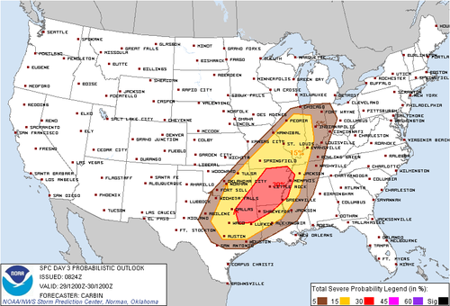
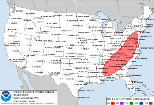
weather for many areas. The Storm Prediction Center has issued areas of
concern for both Tuesday, January 29th as well as Wednesday, January
30th, which are presented below. Based on what I have been looking at, I
will give my best insight into where I believe the threat will be
during the hours of January 29th into the morning of the 30th.
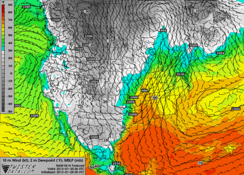
The 00Z NAM model is in fairly good agreement now with the past few runs of this model and the 00Z GFS model has begun to come around to a more similar solution to what the NAM has been advertising over the past day. Therefore, I will only show the 00Z NAM model figures below, keeping in mind that the 00Z GFS model is similar but running a few hours faster than the 00Z NAM model.
The first image below is dewpoints from 06Z Wednesday, as this is when they will be maxed out for most areas that have not had the front pass them yet. Dewpoints in the mid to upper 60s will exist across most of Louisiana and Mississippi during this time frame with 60 degree dewpoints extending as far north as Illinois. It is also important to note the strong southerly flow in the warm sector.
CAPE values will be limited across the severe weather region but a large swath of 500 J/kg or more should exist throughout the day and overnight along the lead edge of the front. While this is not a large amount of CAPE by any means, there will be enough forcing from other means to trigger storms. The biggest factor that the limited CAPE could play into is limiting the threat for supercells in front of the main squall line. However, as can be seen in the image below, which is once again for 06Z Wednesday, CAPE values may surpass 750 J/kg and near 1000 J/kg during the overnight hours, which is not bad considering that it is night and that values struggled to reach this during the day.
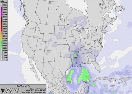
Couple these CAPE values with an intense low level jet, which will strengthen overnight, and the threat for tornadoes will certainly exist across portions of Arkansas, Louisiana, Mississippi, and Tennessee. The tornado threat should also be greater at night as the trough begins to rotate from a positive tilt into a more neutral to negative tilt by morning, helping to aid in more cold air aloft, which is likely helping to raise the CAPE values too.
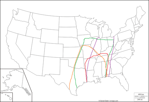
In my forecast I have taken into account where dewpoints of at least 55 will exist, taking into account where precipitation will be occurring during the time frame as well. This I have outlined in the green color. Next in orange I outlined an area which should see CAPE values in excess of 500 J/kg. Next I looked at where low-level winds will be strongest by viewing surface winds up to 850 mb and I outlined this area in purple. I viewed EHI values as well as helicity values to determine where these values were the best and outlined that area in red.
This information, coupled with my general meteorology knowledge and having started following this system since it was over 300 hours away, I have come up with the following map depicting the areas most at risk for damaging thunderstorms during what the SPC will consider the Day 2 time period when they issue their new outlook in less than one hour. The yellow area represents an area where I would expect to see isolated to scattered wind damage and the red area represents an area where I would expect to see more scattered to widespread wind damage reports. The red area receives this heightened threat due to the fact that lower level winds will be stronger at night and this is when the storms will impact this area. Additionally, this area is also at risk for a few tornadoes as I outlined my best tornado threat area in pink.
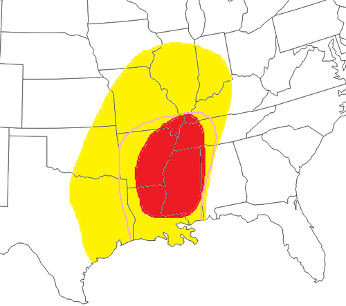
Overall I would expect this to be mainly a damaging wind event given how strong the low-level winds are and that the main storm type should be linear. However, even with the limited CAPE values, especially in the nighttime hours I would not rule out a few tornadoes. The threat of tornadoes could be higher if supercells can form out in front of the main line of storms but this will likely not be known for sure until the event draws closer. Definitely stay tuned to wherever you get your weather information and be on the lookout for another blog from me tomorrow night to update my forecast.
No comments:
Post a Comment