Sunday, May 12, 2013

Lake Effect Tonight and Frost Tomorrow Night

Lake Effect

Lake effect rain and snow showers will likely get started shortly after sunset tonight and will continue throughout the overnight.  At this point it looks like if you are inland of Lake Ontario that the atmosphere should be cold enough in the low levels for a complete changeover to snow by midnight.  This activity will start across the northern half of Jefferson and Lewis Counties and sink south to around southern Jefferson and central Lewis Counties around midnight.  By sunrise the lake effect rain and snow will centered across the Tug Hill area.  As temperatures warm with sunrise, the lake effect snow will begin to change back to all rain by late morning and the band itself will continue to sink south slowly, perhaps reaching a few areas just south of the Tug Hill region.  By early afternoon if any lake effect rain is around it should begin to break up quickly as 850 mb temperatures warm and create a less favorable environment for lake effect.  The band may also move slightly north before dissipating.  To the right is what I expect for snowfall totals tonight and early tomorrow morning.  The gray area will have snowflakes possible tonight, the light blue area will have snowflakes likely with a dusting of snow possible, and the darker blue area will probably see a dusting a snow and perhaps up to an inch or so in some areas.

The Frost

Tomorrow night we transition to colder temperatures than tonight even.  Without the lake effect clouds and the stronger winds helping keep the temperature a bit warmer at the surface, temperatures will plummet.  A widespread frost can be expected for all areas in the north country with the exception of a few areas near the lake shore that will be protected by the warmer lake waters.  While most areas will see temperatures fall to between 27 and 32, a few areas could see mid 20s for low temperatures.  Regardless, everyone should take measures to protect their plants tomorrow night (and tonight also).  Fruit trees that have blossomed should only receive minimal damage to their blossoms but if temperatures do fall into the mid 20s, preventive measures to save the yield of the trees will be needed.  To the right are the predicted lows from the National Weather Service for tomorrow night.

Stay warm everyone, warmer weather is on the way!

Friday, May 10, 2013

Lake Effect Snow Sunday Night!?

Please tell me this is a joke!

I wish I could...  It may be mid-May but unusually cold air associated with a deep upper trough will affect Upstate New York and other areas of the upper Midwest and Northeast one more time (this should be the last frost for northern New York until fall).  Lows Sunday night will drop into the low 30s, resulting in frost in some areas of northern New York.  By Monday night, temperatures will likely drop into the upper 20s for regions away from Lake Ontario.  This will result in a widespread frost for many areas of northern New York.  As if this was not enough shock for everyone who has been waiting to kick Old Man Winter for good this year, some residents to the east of Lake Ontario may witness a certain white precipitation on Sunday night into early Monday morning.  I am talking of course about snow.

The Technical Stuff

Sunday night surface air temperatures will drop into the low 30s, as mentioned previously.  Meanwhile 850 mb temperatures are forecast to drop at least to the low 20s and perhaps the upper teens.  This magnitude of cold air aloft will be enough to create instability across Lake Ontario, as the current water temperature of the lake is 44.  Typically, at least a 13 degree Celsius temperature difference between the 850 mb temperature and the lake temperature is needed to be favorable for lake effect snow development.  Sunday night this temperature difference will exist from shortly after sunset into Monday morning.  The temperature profile will also be conducive to any precipitation that does form to fall in the form of snow away from the lake shore area.  Other parameters that are needed for lake effect snow development that will be in place Sunday night include less than a 30 degree wind shift between the surface and the 850 mb level, with most of the night having less than a 15 degree shift, and abundant moisture for the majority of the night in the boundary layer.  Additionally, the lake equilibrium level will be right around 10,000 feet the entire night, which is also favorable for lake effect snow development.

Where might this occur?

Taking all of this into consideration, it appears likely that at least a band of lake effect snow showers will set up on Sunday night to the east of Lake Ontario.  The band appears at this time that it will form over central Jefferson and north/central Lewis Counties and shift southward throughout the overnight.  The snow band will likely fall apart around sunrise Monday morning over the Tug Hill region.

Do I need to break out my shovel and snowbrush again?

Probably not.  While snowflakes will be in the air across the region, accumulations are probably not likely at this point.  Due to recent warm weather, ground temperatures have warmed significantly and the snow will probably not become heavy enough or last long enough in any one area for accumulations to occur.  However, minor accumulations under a half inch are not impossible if the band happened to become heavier or sits in one place for a few hours.  Minor accumulations are most likely on elevated surfaces, such as your car or hand railings.

Optimistic Closing Remarks (for those of you I just severely depressed...)

Now that I have you dreading Sunday night and contemplating your choice of living in northern New York, I will tell you that after this cold snap the weather will turn nice again.  Next week temperatures will slowly climb back to normal and next weekend we may even see slightly above normal temperatures again!  And there are some indications that more summer like weather may start to set in by late May into early June.

Wednesday, April 17, 2013

April 17-18 Severe Weather Update

Severe weather is underway from portions of northern Texas all the way into Indiana.  This system will continue to create severe weather over these regions this evening before beginning to shift eastward tonight.  The Storm Prediction Center has issued a moderate risk of severe weather for both today and tonight as well as tomorrow and tomorrow night.  The threat for today from the Storm Prediction Center is shown to the right, where the moderate risk exists across extreme portions of northern Texas, central Oklahoma, southeastern Kansas, and a section of Missouri.  The threats come in all forms today and tonight.

Tomorrow and tomorrow night, all threats will once again exist but the risk of tornadoes should be lower than today's threat.  To the right our the risk maps from the Storm Prediction Center depicting an area of moderate risk from northwestern Mississippi and southeastern Arkansas northward through extreme western Tennessee and Kentucky as well as the Missouri Bootheel and finally into eastern Illinois and western Indiana as well as a small portion of southwestern Michigan.

The rest of this blog post will attempt to put together what I believe will happen tonight and into tomorrow.  I expect thunderstorms to continue to increase in coverage this evening, eventually forming into a line of storms tonight which will continue into tomorrow morning.  The main concern here will be with the early discrete cells as well as with any cells that can form in front of the main squall line as the environment is set up well for rotating updrafts to lead to tornadoes within some of these storms.  Outside of these discrete cells, the squall line's main threat will be wind damage but some large hail as well as a few tornadoes will also be possible.  To the right is my threat area, with the red shaded area depicting the area with the greatest risk for severe weather, including tornadoes.

Tomorrow the squall line will continue to push eastward bringing about likely widespread wind damage reports in areas.  Once again, if discrete cells can get going in front of the main squall line, the tornado threat could be higher.  This is possible across the southern portions of the threat area.  However, there will likely be a tornado threat associated with the squall line itself as well, as a highly sheared environment with high helicity values will exist.  My threat area for tomorrow and tomorrow night is shown to the right, with the best threat for wind damage and a few tornadoes shown in red.


If you live in any of these areas please remain alert to the weather conditions over the next 36 hours.  Be sure you know what to do in case severe weather.

Lastly, I will leave you with two target cities where I would head to if I were storm chasing tonight or tomorrow.  For tonight, given where storms have already fired and where I believe they will continue into the overnight, I would say the best chance of seeing severe weather, including tornadoes, would be starting in Ardmore, OK and heading west throughout the night towards Fort Smith, AR.  For tomorrow, I would start in the afternoon around El Dorado, AR and continue towards the northwest heading into the evening toward Oxford, MS.  Now these are just my initial thoughts and obviously with storm chasing initial preparation should be altered as the most current information and conditions arise.

Stay safe everyone!

Monday, April 15, 2013

Severe Weather Poised to Strike Again

Last week's severe weather outbreak was largely a bust despite the system producing nearly 400 damaging wind reports, over 350 severe hail reports, and 40 tornado reports in six days.  Eight of these tornado reports were associated with an EF3 tornado that touched down in eastern Mississippi and traveled just over 68 miles into western Alabama, leaving one dead and nine injured.  However, most weather models overpredicted the amount of moisture that was present in front of this system, which led to a threat in reality that was less concerning than was once predicted.  If a more unstable air mass had been present, this system would have likely produced many more severe weather reports, including more long tracked, violent tornadoes.  The Storm Prediction Center noted this issue when describing their somewhat busted forecasts and stated that this tends to be a concern for the first early severe weather season system.

Well, here we go again, as another system approaches many of the same areas as last week's system.  This time the concern that the models will overpredict the amount of moisture present should be significantly lower.  This is due to the amount of moisture left behind by the last system as well as continued return flow from the Gulf of Mexico across most of the threat regions.  A dry line and stationary front today and tomorrow will remain nearly stationary until Wednesday when it begins to push east, reaching the east coast by Friday.


The largest threat at this point is expected to occur on Wednesday and Wednesday night.  The Storm Prediction Center has issued a Day 3 moderate risk for portions of central Oklahoma, southeast Kansas, and extreme southwest Missouri.  This is only the twelfth time the Storm Prediction Center has issued a Day 3 moderate risk since the first one was issued for a June 10, 2005 event.  Of the 12 events, four events resulted in the issuance of a Day 1 high risk.  These events resulted in varying reports of severe weather but all resulted in some reports.  The June 10, 2005 event recorded the least amount of severe weather but this also comes at a time when severe weather reports were not reported as frequently as today.  In this event, only 4 tornado reports resulted along with 55 wind damage reports and 59 severe hail reports. However, some events that prompted Day 3 moderate risks that were later upgraded to Day 1 high risks resulted in much more historic events, such as April 27, 2011 and April 14, 2012.

The risk on Wednesday does appear that it could result in all forms of severe weather, including the potential for strong tornadoes.  To the right is my threat outlines for Wednesday and Wednesday night defined by an area that has the potential for CAPE values above 1000 J/kg within the area outlined by the orange line, potential for convective type precipitation within the area outlined by the green line, bulk shear values greater than 40 knots within the area outlined by the brown line, 0-3 km helicity values greater than 300 meters squared per seconds squared within the area outlined by the red line, and 0-3 km EHI values greater than about 3 within the area outlined by the pink line.  All of this information was used for me to come up with my threat area to the right.

This threat area is very similar looking to the current Day 3 threat issued by the Storm Prediction Center, with a slight risk being portrayed in yellow and the moderate risk where tornadoes would be more likely being shown in red.  The Storm Prediction Center also has a threat area on Day 4 and this is shown below.  I have put together a tentative map of my threat area for this day as well, which will be Thursday and Thursday night.  This day should have fewer severe storms than the previous day due to lower CAPE values and weaker shear values.  However, the threat for an intense squall line to develop is one that could bring widespread damaging wind reports.  The threat for tornadoes will exist but Wednesday and Wednesday night should have a better chance of these.


Once again my threat looks similar to the current Day 4 threat where the Storm Prediction Center has outlined the 30% area of severe weather within 25 miles of a point.  I do not think they will introduce another Day 3 moderate risk tomorrow for Thursday and Thursday night, but I think the area I outlined in red will include a 30% probabilistic at this point.  If as the event gets closer the wind damage threat becomes more apparent or a greater threat of tornadoes appears to evolve than a moderate risk will likely be warranted at that time.

Stay tuned for further updates on this weeks developing severe storms situation!

Monday, April 8, 2013

Update: Early April Severe Weather Outbreak

Severe weather is currently underway across portions of eastern Colorado, western Kansas, and western Nebraska.  The Storm Prediction Center's latest Day 1 Convective Outlook to the right shows how the convection will spread to the east overnight, affecting areas of northern Kansas and southern Nebraska.  The severe weather threat tonight will include all hazards, with some large hail, damaging winds, and a few tornadoes.


The threat will ramp up more tomorrow as a slightly positively tilted trough continues its push eastward.  The warm sector in front of the associated dry line and cold front will be the main focus for severe weather during this period, which is reflected in the Day 2 Convective Outlook from the SPC to the right.  Once again, all severe weather threats will be possible with large hail, damaging winds, and perhaps a greater tornado threat.


By Wednesday, the trough will remain positively tilted but will continue moving eastward, refocusing the severe weather threat a little further to the east.  The Day 3 Convective Outlook from the SPC is seen to the right.  All severe weather threats will again be possible though the main threat on this day will likely be damaging winds as a large line of thunderstorms should develop.


The animation below shows the 00Z NAM model run depicting composite reflectivity from tomorrow afternoon through Wednesday morning.  I circled areas of severe thunderstorm risk in orange and circled areas with an enhanced risk of tornadoes in red.  Below this is the same thing but for the period running from Wednesday morning to Thursday morning.


A limiting factor to the overall tornado threat during these periods will be a relatively weak low-level jet in most areas.  Additionally, helicity values should remain relatively low in most areas as well.  If these values had been higher the tornado threat could have been much more substantial.  Nevertheless, a strong line of storms will likely produce widespread wind damage reports starting tomorrow evening and continuing into Thursday morning.  Below are my overall threats for tomorrow and Wednesday with the orange area showing where severe thunderstorms could occur and the red area depicting the best threat for tornadoes during each day.


This may end up being the largest severe weather outbreak so far this season, though that is not saying too much given the fairly inactive season so far.  People within these threat regions should pay close attention to their local weather sources and make sure you have a plan in place in case of severe weather, especially tornadoes.

Friday, April 5, 2013

Early April Severe Weather Outbreak

A potentially major outbreak of severe weather could be in store from portions of the Plains into the Deep South early next week.  This probably could have been predicted months ago when I elected to leave Mississippi during severe weather season to present at the Association of American Geographers Annual Meeting in Los Angeles during this same time frame.  Nevertheless, here are some of my early thoughts on the developing situation.

A low pressure system and associated cold front forming in the lee of the Rockies on Sunday will begin to progress eastward Monday.  As this system progresses toward the east it will become the focus for severe weather for at least the early portions of the week.  Major model differences do exist right now with the most notable difference existing between the timing of the system between the GFS and ECMWF models, which are nearly a day apart on the timing of the front now.  The animation to the right shows the GFS model's progression of the 250 mb winds during its past four model runs.  The GFS has moved the trough further east over the past 24 hours and
tilted it more neutrally.  The ECMWF has the trough further to the west with more of a positive tilt in its two past runs, both shown to the right with the 00Z run from last night on top and the 12Z run from this morning on the bottom.  The timing differences here between the two models are rather vast and mean the difference between severe weather on Tuesday or Wednesday for some.  However, the GFS has a bias in pushing these systems through too quickly and thus it is the ECMWF model that should be given more weight.

These are the same thoughts the Storm Prediction Center has also abide by in issuing there latest Day 4-8 Convective Outlook, seen below and to the right.  An enhanced severe threat would be possible over a small portion of western Kansas on Monday, to the northeast of the surface low.  A larger threat area would exist on Tuesday over eastern Kansas, eastern Oklahoma, northeast Texas, western Arkansas, and western Missouri.  Wednesday the threat would move into portions of northern Louisiana, western
Mississippi, eastern Arkansas, southwest Missouri, western Tennessee, western Kentucky, and southern Illinois.  The threats over these three days will include all forms of severe weather with some large tornadoes possible, especially on Tuesday and Wednesday.  Unfortunately, until the GFS comes around toward a solution that is similar to that of the ECMWF, most of the products I am able to look at do not depict an event I believe will actually occur.  Therefore, I have created my own map showing where I believe the threats will be on Tuesday and Wednesday based on limited ECMWF guidance.  The orange outlined area is the area I believe could see CAPE values in excess of 1000 J/kg.  Meanwhile the green line represents the area that according to the ECMWF is at risk of precipitation during this time period.  As of right now, without knowing much more than this, the threat area could really be just about anywhere within this region, which I show in red shading.  However based on some other analysis, I have also tried to outline an area of where I think a greater likelihood of severe weather could occur, which I shaded in pink.  This is my preliminary outlook, I will update this sometime this weekend, especially if the GFS and ECMWF begin to converge on a more similar scenario.

Monday, April 1, 2013

Spring and Severe Weather Season are Here

After a very warm start to spring last year, this year's below average temperatures that plagued much of the nation have left many wondering whether spring will ever arrive.  To the right is an image from NOAA depicting the temperature anomalies across the northern hemisphere during March.  Many parts of the eastern two-thirds of the nation saw temperature anomalies anywhere from one to as much as five degrees Celsius below average.  However, areas in the southwestern United States actually experienced above normal temperatures.

The reason for this can be seen in the two images at left, with the top image showing the Arctic Oscillation (AO) and the bottom image the North Atlantic Oscillation (NAO).  During much of the month of March the AO was negative.  It even reached record negative levels during the later part of the month.  When the AO is negative, the frigid air that is normally confined to the polar regions is blocked and forced to sink into the mid-latitudes.  During this time, if the NAO is also negative then the cold air tends to flow into the eastern half of the United States.  This was also the case for much of the month, especially the mid to late portion.

The red lines in the figures above depict the model forecast for these indexes over the next half month.  As can be seen, after one last cold shot of air this week, the AO is forecasted to spike well into the positive numbers.  During this same time, the NAO is forecasted to continue to trend towards neutral to perhaps even slightly positive.  This is a signal that spring is here!  The latest temperature outlook from NOAA also depicts this, forecasting above normal temperatures across most of the country for the month of April, as seen in the image on the right.  Now that spring has arrived however, severe weather will begin to get rolling with it.  The slow start to severe weather season this year was due entirely to the slow onset of spring and now that spring is here, severe weather will arrive with it.

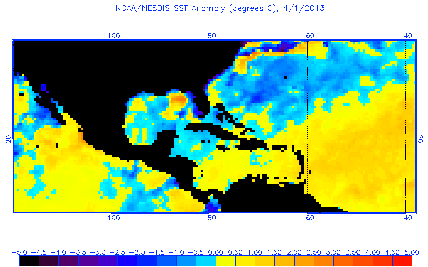
http://www.ospo.noaa.gov/data/sst/anomaly/2013/anoma.4.1.2013.gifOver the past four days, there has already been 242 severe hail reports, 119 reports of damaging wind, and 6 tornado reports.  While the preliminary count of tornado reports thus far this year remains very low, it is important to remember that this year really is not that far from average in terms of tornado reports up until this point.  In fact, 2011 had only 15 more tornado reports to date.  Last year the severe weather season got off to a very quick start due to the early spring.  However, the early spring led to an early summer and thus an early end to the severe weather season.  This year our spring has started much later but the risk of the onset of summer leading to an early end of severe weather season exists yet again.  This is because if the AO and NAO go positive and stay positive, cold air will be cut off from the United States.  Additionally, a neutral SOI tends to be correlated with lesser amounts of severe weather across much of the nation.  Lastly, if we take a look at the current sea surface temperature anomalies on the left, we see that sea surface temperatures are below average for most of the Gulf of Mexico and Atlantic seaboard.  Taking all of this into account, while there will definitely be severe weather this spring, especially during the month of April, I do not expect this to be an above normal year for severe weather.  However, it probably will not end up being as quiet as last year was overall.  Therefore, the next couple months will likely become active.

That being said, it appears that a severe weather outbreak will be possible next week though the exact placement of the event is still unknown.  Warm air and moisture from the Gulf will begin to surge northward starting later this week and this will ripen the atmosphere for severe weather.  Areas that should keep a close eye on this involving situation range from the southern and central Plains to the Southeast and Midwest.

Monday, March 18, 2013

March 18-19 Winter Storm

A winter storm is currently moving into upstate New York and will affect the North Country region this evening into Tuesday.  I just wanted to make a few quick notes on this system for everyone.

Timing:

The snow should begin moving into the southern portions of northern New York just before sunset and quickly spread across the rest of the eastern Lake Ontario region within the couple hours after sunset.  The snow will continue all night, becoming heavy at times.  The snow will continue Tuesday though it should be lighter for the most part.  However, there could still be a few heavier snow showers around at times.  The snow should come to an end Tuesday evening.  However, some areas to the east of Lake Ontario will immediately begin to pick up lake effect snow after this system pushes away, leaving no true break in the snowfall.

Precipitation Amounts:

The snow will be somewhat heavy at times across the region but there appears to be some large differences in where the snow will stay steadiest the longest.  The heaviest snow will likely fall in the few hours around the midnight hour.  The 18Z run of the NAM model (right) depicts liquid equivalent precipitation totals ranging from a quarter inch to around one inch.  In this scenario the heaviest snow would fall in the Tug Hill region and the lower totals would be across central St. Lawrence County.  Meanwhile, the 12Z run of the ECMWF model tends to show the same areas of high and low precipitation totals but the higher amounts across the Tug Hill are only around 3/4 of an inch.  The 12Z Canadian GEM model appears to have a similar solution to the 12Z ECMWF but may also bring through a heavier area of precipitation early Tuesday morning.  The 12Z run of the GFS model (right) is potentially the worst (best) case scenario, blanketing the north country in at least half an inch of precipitation with areas of near or just over an inch across a large area.  This would result in snowfalls of 6 inches or more across the entire area if this were to come true.

Snow Ratios and Amounts:

The snow growth region for this event will begin around 12,000 to 14,000 feet, which means there is a lot of time for riming to occur (condensing of the snowflakes).  However, the region below the snow growth region should remain at or below freezing all night.  Taking this into consideration, it appears that snow will begin with a snow ratio around 15:1 tonight.  Tomorrow, as the snow growth region falls and the only concern becomes the temperature of the surface, snow ratios will increase to 20:1 for much of the day and likely to around 30:1 by nightfall (this is when the lake effect would be beginning and the general show showers would be wrapping up).  Some areas may see a changeover to rain during portions of the afternoon tomorrow closer to the lake shore.

So knowing the ratios and the precipitation totals, it is possible to come up with some snow amounts for the area.  I think on the low end, 2 to 3 inches should be expected for the whole area.  However, higher amounts will likely occur for many areas, especially the Tug Hill area.  Across the Tug Hill, amounts up to a foot may fall before the lake effect starts up tomorrow night.  My map to the right is my best general prediction at this point of how much snow may fall by tomorrow evening.  The gray area will see the lowest amounts, generally 2 to 4 inches in this region.  The blue region can expect 3 to 7 inches with perhaps a few isolated areas up to 10 inches.  The heaviest amounts will be in the pink region where amounts of 6 inches or more will be likely.  A few areas in this region could get a foot or more of snow, as I mentioned previously.

Lake Effect:

I will not comment that much on this in this post, but figured that I should mention it.  There will be a period of lake effect snow following this system for Tuesday night into Wednesday.  The most likely area to receive this will be east of Lake Ontario and amounts will likely prompt a Lake Effect Snow Warning for this region.

Impacts:

Travel will become difficult after nightfall this evening as snow moves into the area and will likely stick to roads fairly quickly with the sun being down already.  Additionally, winds will become stronger tonight and thus have promoted a wind advisory for the area.  This will cause blowing and drifting snow and lead to whiteout conditions.  Winds will become sustained around 20 mph with gusts to 50 mph in some areas, especially those favored for high winds under a southeast flow, such as areas to the northwest of the Tug Hill Plateau.  Take it easy, especially tonight, if you need to travel.  Winter is not over yet!

Friday, February 8, 2013

2013 Chasing Days

Want to know when your best chance to go storm chasing will be?  In a new segment on my blog, I will post periodic updates informing you of when your best chance of tracking down that big storm could be.

Based on the latest model guidance, these are the days I consider their to be a chance of severe weather in the short to medium range.

February 9th

The latest Day 2 Outlook from the SPC shows a slight risk of storms across portions of northern Texas and southwest Oklahoma.  The main threats here will be wind along with the potential for a tornado or two and some small hail.  These storms will occur along and just in front of a sharp cold front pushing east through the region.  Limited moisture and instability will keep this threat relatively low.

February 10th

The latest Day 3 Outlook from the SPC depicts a slight risk of severe thunderstorms across eastern Texas, most of Louisiana, and western Mississippi.  These storms will be associated with the same warm sector and advancing cold front as the previous day's storms.  Once again, limited moisture and instability will preclude a more significant threat.  Nevertheless, damaging winds will be the main threat along with some potential for marginally severe hail and a couple tornadoes.

February 11th and 12th

Thunderstorms may continue in some limited instability and moisture along areas of the Gulf Coast and across southern Georgia and northern Florida.  Once again this should be a limited threat with only a few damaging wind reports or hail reports.  Shear values support a weak tornado or two.


February 13th

Thunderstorms will exist across portions of central Florida during this period.  Moisture will be fairly good but instability will be limited still.  The main threats should be damaging winds and some marginally severe hail though a tornado or two cannot be ruled out, especially in the northern sections of the threat area.


In this section, I will give some estimates on severe weather dates in the long term.  These dates are not based solely off of model guidance but rather based on information from teleconnections and other knowledge.  It is important to remember that these dates are far from set in stone and the farther away they are, the more likely they are to change.  But I figured hey, let's have some fun and see how close I can come on some of these springtime events.  Below is what I am thinking for events through about Mid-April.

February 19th - Southern Texas
February 20th - Gulf Coast
February 21st - Florida
February 24th - Southern Plains
February 25th - Mississippi Valley
March 6th - Mississippi Valley
March 7th - Deep South
March 21st - South/Central Plains
March 22nd - Deep South
March 23rd - Southeast
March 25th - Mississippi Valley
March 26th - Southeast
March 30th - Southern Plains
April 2nd - Southeast/Midwest
April 4th - South Plains/Mississippi Valley
April 5th - Southeast
April 10th - South Plains/Mississippi Valley
April 11th - Southeast

Be on the lookout for my next update in a few days!

Thursday, February 7, 2013

Update: February 7-9 Northeast Winter Storm

Surface chart as of late this afternoon
A major winter storm is set to begin tonight and continue through Saturday night in some areas of the Northeast.  A low pressure system, currently located around northern Illinois, will move east tonight into northern Ohio by morning.  Meanwhile, another low pressure system, currently located along the Georgia and Florida border, will push up the east coast tonight reaching the North Carolina coast by morning.  By Friday evening, the coastal low will be located off the coast of New Jersey and Delaware, where it will merge with the energy from the Midwest low pressure.  As this happens, the coastal low will deepen dramatically reaching sub 980 mb readings according to the 18Z runs of the NAM and GFS.  The peak strength of this low will be overnight Friday off the coast of New England.  This will be when the heaviest snow falls and when the gustiest winds occur then.  By Saturday morning, the low will start to weaken and move slowly to the east throughout the day.  Only a few lingering snow showers will likely remain across portions of New England, especially near the coast, by the time Saturday night comes around.

So when can you expect the precipitation to begin in your area?

To the right is a map I made depicting the onset of the precipitation from either of the lows.  The earliest onset of precipitation is occurring right now across areas near Lake Ontario as snow slowly begins to cover this area.  By tomorrow morning, snow will be covering many areas across Upstate New York, Vermont, and the western portion of New Hampshire, Massachusetts, and Connecticut.  Most of this will be in the form of snow associated with the low originating from the Midwest.  Precipitation will also be occurring across Ohio from this low.  Meanwhile, the coastal low will be responsible for rain, snow, and sleet starting by tomorrow morning across eastern Pennsylvania, New Jersey, and the lower portion of New York and Connecticut.  By midday precipitation will encompass most of the Northeast.  Northern Maine will be the last are to see the onset of snow, occurring either tomorrow afternoon or tomorrow night.  It should be noted that this denotes only when the precipitation will begin for an area and not when the heaviest snow will be.

So when will the heaviest snow fall in your area?

To the right is a map I made showing when the heaviest snow will likely fall in each area.  Keep in mind that this is the heaviest snow with respect to each area.  This means that some areas will receive heavier snow than others but this map does not take that into account.  In general, the areas receiving the heaviest snowfall will begin in the west and move toward the north and east as the time period progresses.


So how much snow can you expect?

Snowfall totals are still in question for some areas as the exact track of the lows, especially the coastal low, could result in drastic changes in snowfall.  For instance, in the 18Z run of the NAM and GFS models, the NAM runs the coastal low a little closer to the coast.  This means the difference between 18" plus of snowfall for New York City with the NAM track and 5" to 10" for the GFS track.  With that in mind, to the right is my prediction for snowfall totals starting this evening through Saturday night from this system.  This will be the first major winter storm for many of these areas in nearly two years.  The heaviest snowfall
totals appear as though they will span from near New York City northeastward into southern Maine.  One thing to consider is that especially along the coast, strong winds will also accompany this snowfall resulting in blowing and drifting snow.  To the right is what I expect for wind gusts during the event.  For most areas wind gusts will only cause minor drifting and blowing.  However for coastal Maine, southeast New Hampshire, eastern Massachusetts, Rhode Island, Connecticut, and Long Island, winds could cause major drifting of any accumulated snow and result in some isolated power outages from falling limbs and perhaps a few trees.  People in these areas should be prepared for the worst case scenario that they could be without power during the winter.  Temperatures Saturday night after the storm will be quite cold too with most areas getting down to 20 or lower.  Some areas will even see temperatures at or below zero.

Bottom line, if you do not need to travel during this storm, don't!  Stay safe everyone.

Wednesday, February 6, 2013

February 7-9 Northeast Winter Storm

A winter storm will impact portions of the Northeast beginning Friday and continuing through Saturday Night.  While confidence is high that this winter storm will form, differences in model tracks and timing have left some questions.  Below are the 12Z and 18Z GFS and NAM model runs depicting snowfall through Saturday evening.


The main difference here is the GFS starts the formation of the low pressure off the coast of the Carolinas about 6 hours sooner than the NAM model does.  This time difference results in the precipitation shield reaching the Northeast sooner and more of the precipitation falling overnight.  The nighttime temperatures will be more conducive for snow or sleet to occur at the surface and thus accumulations could occur.

The other difference is in the track and strength of the low pressure.  The 18Z GFS model is depicted to the right and the 18Z NAM model is depicted below that.  The NAM model takes longer to mature the low and keeps it farther off the coast than the GFS model.  The result is a more impressive look to the GFS but the NAM is still able to achieve similar snowfall amounts in most areas due to its higher QPF (Quantitative Precipitation Forecast) totals.  This is likely due to its better understanding of processes related to the deformation zone as well as stronger PVA (Positive Vorticity Advection).
Another major difference has to do with the phasing of the energy between the shortwave cutting through Michigan and Upstate New York and the Coastal Low.  The NAM model appears to hold off on phasing these energies until after the Coastal Low is north of New York City.  Meanwhile, the GFS phases the energies much sooner, in the vicinity of New York City, about at the point when the low begins to push more east, rather than north.  This earlier phasing helps to strengthen the low and produce heavier precipitation amounts across the New York City area instead of out to sea and along coastal Maine as the NAM does.

Keeping in mind these model differences, a major snowstorm will impact portions of the Northeast beginning Thursday night.  Given what the current American models are thinking, I would lean closer to the GFS solution as it seems to have a slightly better handle on how the energy will evolve.  Additionally, it has been the more accurate model thus far for this event, predicting better what would happen today over Texas with a portion of the energy that will help create this Coastal Low.  The Arctic Oscillation is also forecast to be slightly negative, which could be further evidence for favoring the GFS solution.  Another way to verify this thinking is to consult the ECMWF model.
The ECMWF model has a track of the low that is very similar to the GFS model.  One reason for the similarities in these models is they are both global models, which means they are able to take into account information from the whole globe and produce an output for the globe.  The NAM model on the other hand only takes into account information from around North America and therefore only has an output in that same area.  One major similarity between the ECMWF and GFS then is that they both forecast a strong area of high pressure (ridging) that results in the stalling of the Coastal Low off the coast of New England (as shown in the image with the black line showing the blocking ridge).  This results in a longer period of precipitation as the low slowly moves and may have been why the GFS phased the energies better as previously mentioned.  The NAM model does not depict as strong of a high pressure due to its limited domain.  Therefore, it continues the Coastal Low on a northern track instead of stalling it.  Now it is likely that as the event draws nearer that the NAM model will understand the effects of the high pressure more, but for now this is a major influencer of the Coastal Low track that the NAM is missing.  The GFS and ECMWF both forecast the ridge to begin breaking down over the Atlantic Ocean late Saturday night.  This would allow the Coastal Low to begin moving out to sea as opposed to northward as the NAM model has depicted.  This will result in major snowfall forecast differences in the northern portions of Maine, New Hampishere, and Vermont.
So what am I thinking in the way of snowfall amounts then?
Well, given the overall better solution of the track via the GFS and ECMWF but better feedback via the deformation zone by the NAM and ECMWF, I will go with a blend of the best qualities of all of these models.  Below is my snowfall totals for the event across the Northeast.  This is subject to change but as of right now this is my best estimate.

The snow will be combined with strong, gusty winds in many areas, especially along the coast too.  This will result in blowing and drifting snow, making travel almost impossible at times Friday and Saturday.  Stay tuned to this evolving situation.

Monday, January 28, 2013

Severe Weather Update!

My initial thoughts on the severe weather outbreak that will begin tomorrow have changed only slightly since last night when I first posted them.  For those who may not have seen my post from last night, here is the link to it.  At the time the Storm Prediction Center (SPC) was about to issue its first Day 2 Outlook for this event, which can be seen below.

image

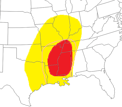
This outlook looked very similar to the previously issued Day 3 Outlook but had some major differences when compared to the map I posted just a hour before they issued their outlook, which can be seen below.
image

While I did not disagree with the location of the 30% risk issued by the SPC, I questioned their reasoning for not continuing this risk into the night, downstream of their current region.  It appeared the only reason may be a concern about decreasing instability overnight but as I viewed the models again, I was confident this should not be a limiting factor.  In fact, as I will show further in this post, the best instability will actually be during the early overnight hours.

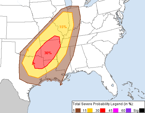
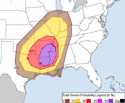
Late this morning during the next issuance of the Day 2 Outlook, the SPC issued an outlook which was much more in line with my previous thoughts from the night before, as can be seen below.  In fact, a moderate risk was even issued for some areas (seen here as the 45% hatched region).  This new outlook actually raised some areas in Mississippi from a 5% risk of severe weather within 25 miles of a point to a 45% chance of severe weather within 25 miles of a point with at least a 10% chance of significant severe weather, a very drastic change!
image

This will be the first significant severe weather outbreak of the year, with tens to hundreds of damaging wind reports expected and perhaps a few tornadoes as well.  Just how significant might this event be?

Well, over the past 15 years, only five Day 2 moderate risks have been issued in January by the SPC.  What happened those other four times?

January 22, 1999: 43 tornadoes, including 2 F3 tornadoes, injured 20 people and killed one across Alabama, Arkansas, Illinois, Kentucky, Louisiana, Mississippi, Tennessee, and Texas resulting in about $76 million in damages.

January 3, 2000: 11 tornadoes, including 3 F3 tornadoes, and 101 wind damage reports resulted in 21 injuries across Arkansas, Indiana, Kentucky, and Mississippi resulting in about $72 million in damages.

January 2, 2006: 18 tornadoes, including 1 EF3 tornado, and 73 wind damage reports as well as 107 reports of 3/4” hail or greater resulted in 5 injuries across Georgia, Florida, Illinois, Kentucky, and Missouri resulting in $7 million in damages.

January 13, 2006: 19 tornadoes and 45 wind damage reports injured 34 people and killed one across Alabama, Florida, Georgia, Louisiana, North Carolina, South Carolina, and Virginia resulting in $7 million in damages.

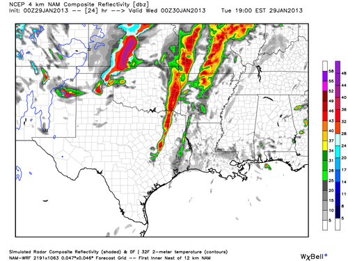
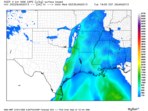
Needless to say, a multi-million dollar day in damages could be ahead of us based on these prior events.  So let’s take a look at the details using the 00Z NAM model run.  I expect that thunderstorms will be ongoing at the start of the day in the Oklahoma area and will quickly expand in coverage throughout the morning across the western portions of the threat region.  It appears initial convection will begin to form into a squall line rather quickly, though a few discrete cells out in front of the line in Arkansas, Missouri, or Illinois may not be out of the question.  By afternoon instability will be on the increase as evidenced by the image below showing CAPE values during the evening.  This will allow the squall line to intensify as it becomes more organized across Texas, Arkansas, Oklahoma, Missouri, and Illinois, as shown by the simulated reflectivity image below for the same time as the CAPE image.
image

image

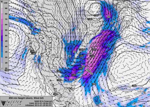
As night falls, expect CAPE values to remain steady or rise slightly in front of the squall line as the trough becomes more negatively tilted.  This will allow colder air to flow in aloft resulting in steeper lapse rates and these better CAPE values.  Additionally the low-level jet will really strengthen after nightfall, aiding in shear values which could improve the chances for tornadoes as well as the chances for wind damage.  This low-level jet is shown for around the midnight hour and it can be seen that many areas will have wind speeds of 50 knots or greater just  a few thousand feet above the surface.
image

This could strengthen effects of the squall line even further as shown by the simulated radar image below for around midnight.  One other serious thing to note on this radar image is something the NAM model has been advertising more and more today and it will be interesting to see what the RAP and HRRR models have to say about this soon when they begin to predict out this far.  That thing is, discrete cells in front of the squall line.  According to the latest run of the NAM, these cells may start up in southern Mississippi and southern Alabama a couple hours after dark and rapidly speed toward the north northeast at 40 to 60 mph.  Current indications are that these discrete cells could affect portions of Mississippi, Alabama, and Tennessee before being overtaken by the fast-moving squall line in the early morning hours.
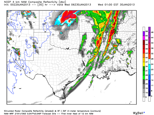
image

If these cells do indeed form, they will have incredible speed shear to work with and some directional shear.  This shear has resulted in large helicity values across the aforementioned region and EHI values could also be fairly good for this time of year.  The EHI values for around midnight are shown below.  It is important to note that while the RAP model does not show out this far in the future yet, comparing times that it does go out to with the NAM solution has indicated that the RAP believes that EHI values could be stronger than the NAM depicts.  Stronger EHI values could show a greater chance of tornadoes during the overnight hours.
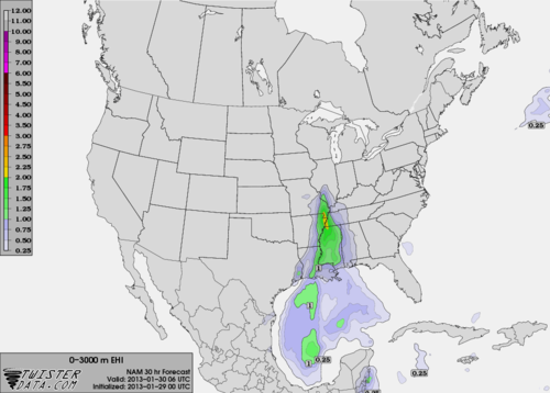
image

Another thing that could aid in the evolution of supercells during the night is what the NAM model indicated could occur during the afternoon hours across portions of Mississippi and Alabama.  This thing is a clearing in the clouds.  If the clouds do clear for a bit or even thin during the afternoon hours, daytime temperatures could raise quickly resulting in higher values of CAPE and a much more unstable atmosphere.
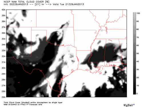
image

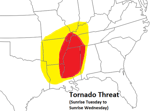
After the early morning hours, discrete cells should begin to die off and merge with the squall line as instability wanes.  The squall line should also weaken some as we head into sunrise.  Given all of this information I have produced a couple more maps below indicating my threat regions for wind damage and potential for tornadoes.
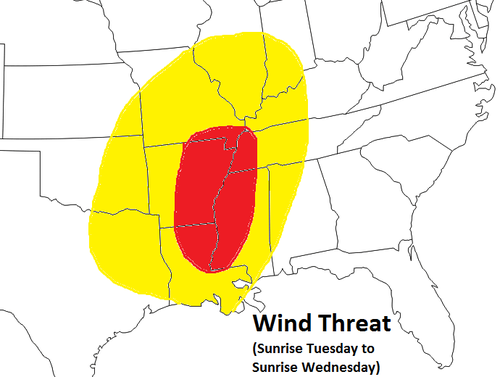
image

image


Tomorrow and tomorrow night will certainly bring about many wind damage reports.  Tornadoes will certainly be a possibility, especially if those discrete cells form overnight.  Nevertheless, any sunshine that can peak through tomorrow will enhance the severe weather threat but even without the sun, a potent trough coupled with strong atmospheric winds at all levels will be enough to spark severe thunderstorms.  Keep alert and know where you can get your severe weather information tomorrow and especially tomorrow night.  Try to find a way to get notifications even when you are asleep as these will be the best hours for tornado potential.  Stay safe everyone!