
With a sharp shot of cold
air having pushed its way into the United States, many in the eastern
half of the nation are currently experiencing the coldest air of the
season. Below is the 00Z NAM model sounding for Pittsburgh at 10PM this
evening.
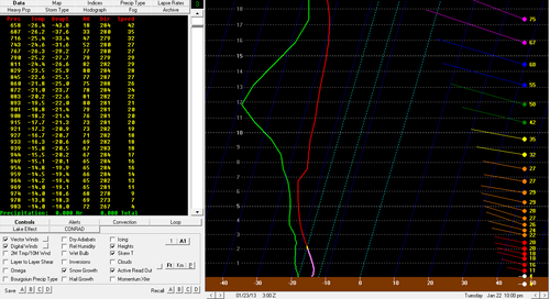
The modeled surface temperature at this hour was around -14 degrees Celsius. This means that the snow growth region actually occurs right at and just above the surface. Knowing this information, what could possibly be showing up on the Pittsburgh radar?
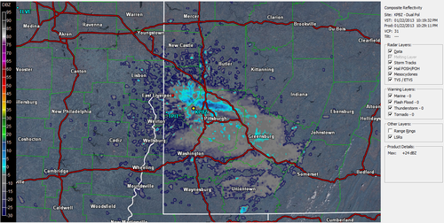
This precipitation is located just north of Pittsburgh and was remaining fairly stationary over time. Give up? Let me give you a little more information. As you may have noticed in the model sounding from above, the forecasted wind direction near the surface was from the west northwest. Notice how this band of precipitation is also located in this orientation. Now I know many of you may be thinking, oh well it must be some kind of lake effect then. Well it kind of is, but what is the source of the water? Need help?
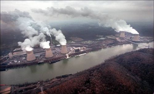
The red dot located just to the west northwest of the band is the Beaver Valley Nuclear Generating Station. It is so cold that the steam being output from the nuclear power plant is forming into dendritic ice crystals and falling as snow across the northern suburbs of Pittsburgh! In fact, the National Weather Service in Pittsburgh has actually received reports of accumulating snowfall up to one inch from this band of snow. Try forecasting that one!
No comments:
Post a Comment