Thursday, March 29, 2012

April Severe Storms Outlook

Originally posted on ZoomRadar

The month of March started off with a bang, producing the worst severe weather outbreak of the season. The event started on March 2nd and continued into March 3rd, producing 65 confirmed tornadoes including nine EF3 tornadoes and two EF4 tornadoes.

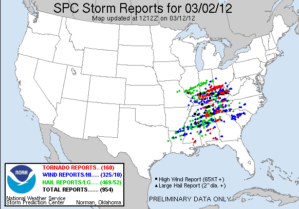
After this outbreak however, it took over a week before the next tornado would be reported. Despite some climatological anomalies, such as a tornado reports in Michigan, South Dakota, and Minnesota, this month has been fairly quiet since the early March outbreak. In fact, the next largest total of tornado reports was 20 which occurred on two occasions, once on the 21st of the month mainly across Louisiana and southern Mississippi and again on the 23rd across the Midwest and parts of the southeast. The number of tornado reports has come no where close to the staggering 160 reports which were received on March 2nd alone.
However, due to the large amount of tornadoes that occurred from that early month outbreak and a few days adding in at least ten tornado reports this month, this year is continuing on its trend as an above average year for tornadoes when considering the 2005 to 2011 average, shown below. In fact, only 2008 had more tornado reports up to this date, with 497 being reported that year compared to this year’s 382.
Will the trend of above average tornadoes continue into April then and can we expect anymore outbreaks in the near future?
For the answers to these questions I will take a look at a few variables which may give us a peak into what April may have in store as far as severe weather goes. The first variable to consider is the NAO, which has remained positive most of the winter. This has allowed for mild air to remain in place over most of the lower 48 states as the jet stream has typically been farther north than usual. However, forecasts are in a general agreement that the NAO should begin to go at least slightly negative as we head into April. From there though it is anyone’s guess as forecasts diverge quickly. If the NAO were to remain negative though, it would allow for some cold air to potentially work its way into the contiguous United States, possibly setting up a battle between air masses which could trigger some severe weather outbreaks.
Another factor to consider is the very warm water which is currently in the Gulf of Mexico. Sea surface temperature readings across this water are easily 1 to 2 degrees Celsius above average with some areas even pushing 4 degrees Celsius above average. This will help bring very warm and moist air into the states anytime a southerly breeze is blowing across this water. Additionally, this warmer than normal water will help keep air temperatures warmer than normal creating for a larger temperature gradient when cold air shots do infiltrate the states.
Additionally, the La Nina pattern we have been in much of the winter is now forecasted to end by the end of April with a return to more neutral conditions. Typically La Nina is responsible for pushing the jet stream further north than usual, which is what we have saw this winter and so far this spring. This allows for severe weather events to take place further north and west of where they would traditionally take place. This is also something we have seen so far this spring with tornadoes occurring in states such as Michigan, Minnesota, and South Dakota as well as numerous tornadoes occurring across the Plains, an areas which typically does not see the peak of their severe weather season until late April and May. So with La Nina weakening and coming to an end, what does this mean for severe weather?
Well, without an El Nino forecasted to take over, the jet stream will be much more susceptible to movement meaning air masses should mix more frequently, leading to at least the potential for more severe weather outbreaks. Of particular note here is the timing of the ending of this La Nina which matches almost perfectly the timing of last year’s La Nina which officially ended around the end of April last year. However, last year’s La Nina was stronger than this year’s so we may not see the same effects as last year’s pattern change, which may be partially to blame for the severe weather outbreaks near the end of last April.
It is important to remember that even with this expected pattern change, synoptic scale events must still occur in order for these outbreak type events to happen and this is not something that can be predicted all that accurately this far in advance. That being said, it does appear that atmospheric circulations are becoming more conducive for severe weather events as we head into the month of April.
So are there any concerns in the short term?
In the short term there will be a few areas at risks for severe storms to end the month of March. While tornadoes cannot be ruled out, no widespread tornado outbreaks should be expected. However, as we enter the month of April we will have to keep a close eye on a trough which should set itself up over the Plains by early next week and continue pushing east as the week progresses. The current Day 4 to Day 8 Severe Weather Outlook from the Storm Prediction Center does highlight an area for a 30% or greater threat of severe weather within 25 miles of a point for Monday and Monday night.
Keep a close eye on this developing situation and look for future blog posts about this potential severe weather outbreak as it gets closer.

Monday, March 26, 2012

Wildfire Risk for Parts of the High Plains

Originally posted on ZoomRadar

A critical to extreme risk of wildfires is currently underway across parts of the High Plains and will continue for the next couple days. This is being caused by an upper-level low which will be crossing the region creating for dry and windy conditions on the western side of a dry line and advancing cold front.

Below are the risk maps for today and tomorrow from the Storm Prediction Center. The maps show a critical to extreme risk for today basically along the eastern slopes of the Rockies with the extreme risk occurring in eastern Colorado, extreme southeastern Wyoming, and extreme northwestern Nebraska. The threat moves tomorrow to include most of Nebraska, southern South Dakota, and parts of eastern Wyoming though no extreme threat is indicated at this time.

The fire risk is being helped out by a lack of moisture over these areas this month as shown below. Most areas inside this risk for wildfires have seen less than 50% of the typical amount of precipitation they would normally see over this time period with some areas even seeing less than 5% of the typical amount of precipitation they would normally see over the past 30 days!
Coupled with this lack of moisture, strong southerly surface winds will aid the problem today and tonight bringing warm and dry air in as depicted by the NAM model below. Sustained wind speeds in excess of 20 knots will be in place across much of the northern section of the threat zone today with some areas even seeing sustained winds up to 30 knots. Below this is an image showing just how much dry and warm air is being advected into this area, with 850 mb temperatures being above 20 degrees Celsius in most of the wildfire risk area this evening and some areas even seeing this number reach above 25 degrees Celsius. Dew points at the surface (not shown here) will also be well below 30 degrees Fahrenheit for most of the areas to the west of this area of 25 degree Celsius or greater 850 mb temperature, showing just how dry this air is.
Tomorrow the cold front will push through switching the winds to a more northwesterly direction but they will still be quite strong for some, especially across the southern South Dakota portion of the threat area as depicted below by the NAM model.
Wind gusts will be even higher across these areas today and tomorrow prompting the issuance of High Wind Warnings across much of the northern High Plains. There have already been numerous reports of small fires across the threat area for today. Luckily, a couple storm systems should bring some chances at rain over the next week for this area, which will hopefully cut down on any long term problems this area may experience this spring due to wildfires.

Thursday, March 22, 2012

Heavy Rains Finally on the Exit

Originally posted on ZoomRadar

An upper-level low which has essentially become cut off from the jet stream and therefore is barely moving has affected many regions of the United States over the past week. The current location of the upper-level low as of this morning was over the Central Oklahoma area as depicted by the 250 mb chart from the NAM model’s initialization.

The good news is the low should finally begin to move eastward with a little more speed today and reach the Illinois to Indiana area by Saturday morning according to the NAM model. The GFS model shows a very similar situation occurring. From here, both models have the upper-level low continuing east, as it does the precipitation associated with it should weaken and push off of the East Coast. Once over the waters of the Atlantic, the cutoff low appears as though it will finally start to be pulled back into the jet stream making way for the next trough to enter from the Pacific.
What is stunning about this low is how much rainfall it dropped across parts of the nation. Below is the observed precipitation amounts for the last seven days ending this morning. As you can see, many areas in the southern Plains and across the Gulf states have been soaked by rainfall from this system. Many places in western Oklahoma, Missouri, Arkansas, northeastern Texas, Louisiana, and Mississippi have seen in excess of two inches of rainfall with some spots seeing over five inches of rain. Some areas in southwestern Louisiana have even seen amounts in excess of ten inches of rain with one place reporting just over fifteen inches from this week’s storms!
When taking into consideration the storm systems that worked through these same areas last week, the rainfall totals become even more impressive. Below is the image of observed precipitation amounts over the last 14 days ending this morning. The red colors depict areas that have received in excess of five inches of rainfall over the past two weeks which includes areas in western Oklahoma, Arkansas, northeastern Texas, Louisiana, and parts of Mississippi. Rainfall totals of over fifteen inches were observed across some areas of Louisiana with some isolated areas receiving close to twenty inches of rain over the past two weeks.
With all of this rain and still more to come for some areas as shown by the current radar image below, many rivers are currently experiencing or are forecasted to experience at least near flood stage to minor flood stage issues.
However, some river gauges, denoted in red and purple colors below, are currently experiencing or are expecting to experience moderate to major flooding, respectively.
Fortunately due to the mild winter across much of the nation, these rivers should recover fairly quickly from this excess rain because they will not have to deal with too much snow pack melt. In fact, as of this morning only 11.1% of the contiguous United States was covered by snow as show in the image below. There is almost no snow in the United States east of the Rockies, with just a few areas near the Canadian border in the northeast hanging out to light snow packs.
Like last week’s storms though, this was welcome news for many in the south to help alleviate drought conditions that have persisted in some of these areas for some time. In the meantime however, be on the look out for flooding and flash flooding. Somewhat more seasonable temperatures and less rainfall should return to the eastern half of the nation as we head into the beginning of next week.

Monday, March 19, 2012

Out Like a Lamb?

Originally posted on ZoomRadar

You know the old saying about March, in like a lion and out like a lamb? Well, March surely started off with a bang considering the month has already tallied over 150 preliminary tornado reports claiming 39 lives. Additionally, over 2,000 high temperature records have either been broken or tied thus far this month and heavy rains have plagued areas of the nation including parts of the ArkLaTex which will see more rain in the next couple days. It has certainly been an active start to the month for extreme weather, but will it continue?

Currently a large trough is pushing its way across the Plains where severe weather will begin to pick up this afternoon into the overnight. This will surely add to the tornado totals as a large area from Texas northward to almost the Canadian border could see tornadoes, large hail, and damaging winds today. The threat will push off to the east tomorrow, though it is expected to be less intense than today.

Following the exit of this system though, what does the rest of March have in store? Taking a look at the 8 to 14 day temperature outlook from NCEP, temperatures will be well above normal for most of the lower 48 to end the month. The only areas of exception are Alaska, which continues to be colder than normal this winter, and the west coast.
The reasoning behind these much above normal temperatures across a majority of the nation is constant ridges which will be in place over the center part of the nation. This will allow for warm air to infiltrate these areas. The 8 to 14 day 500 mb heights and associated anomalies are shown below.
With all of this warm air in place to end the month there are sure to be more high temperature records that will fall but, this also implies that severe weather may be kept to a minimum. Troughs are typically associated with severe weather and with ridges occurring across the center of the nation, severe weather will not find many places to form across the nation. This means that after this current storm system moves through, the rest of March may in fact exit like a lamb.
However with all of this warm air in place, if a shot of cold air could be pushed into the United States, severe weather would result. Currently the NAO is positive, as it has been for much of the winter, which has caused the jet stream over the United States to be much farther north than normal. This has trapped most of the truly cold air north of the United States. Models are beginning to show signs that this trend could be coming to an end, at least temporarily. Pictured below are the NAO observed values and forecasts for the rest of the month. The forecasts are agreeing that the NAO value should decrease as we head toward the end of this month but near the end of the month forecasts diverge, with some forecasting another increase and some continuing the decrease. If the NAO value did decrease, colder air would be able to push into the United States around the start of April which means despite March going out like a lamb, April may come in like a lion. This is definitely something everyone should keep an eye on as it gets closer.
Until then though, enjoy the nice weather that will be across much of the nation to end the month. With the GFS model showing few storm systems moving through, except along the northern edge of the country where the jet stream will be residing, most of the nation will experience above normal temperatures and sunny skies.

Thursday, March 15, 2012

Approaching Severe Weather Outbreak

Originally posted on ZoomRadar

A storm system currently pushing onto the west coast will track its way into the Great Plains on Sunday where severe storms are expected to occur. While many aspects of this storm could change between now and the beginning of the onset of severe weather, it does appear at this point that there is enough of a heightened threat to worth mentioning. The current Day 4 to 8 Severe Weather Outlook from the SPC shows two areas highlighted for at least a 30% probability of severe thunderstorms within 25 miles of a point.

The Day 4 area shows where storms could be on Sunday and Sunday night while the Day 5 area depicts where storms could be Monday and Monday night. There could be a threat beyond this Day 5 area further to the east but at this time there are too many uncertainties about the track of the system to really be able to pinpoint an area at risk for severe storms.
Above is where the storm system is expected to be on Monday morning. Most of the current model runs are showing that the main risk for severe storms would not start until Sunday late afternoon into the evening. That being said, areas just to the east of the dry line would be at the greatest risk for these storms. The cold front should take over the dry line by Tuesday morning and continue to push very slowly to the east, potentially only reaching central Texas by Wednesday morning. So what will be aiding these storms?
Taking a look at the GFS model run depicting what could be happening around midday on Monday, the first thing to consider is a very large trough which will be centered just to the west of the severe storms areas. This trough will help aid in some very strong winds aloft with a very large jet streak occurring over the surface cold front and dry line helping to enhance shear.
Additionally, 850 mb winds out of the south will help aid in bringing warm and moist air into the area. Although the warm air advection does not look that good for all areas, most of these areas will also benefit from the warm air that was already in place thanks to this week’s above normal temperatures. An 850 mb low level jet should also aid the storms, especially north of Texas.
The warm and moist air will be evident along with south to southeast surface winds which will be stronger near the front. Dew points greater than 60 will be widespread in front of the frontal system with dew points greater than 65 across most of eastern Texas. This should provide for a conducive environment for severe storms.
Additionally, CAPE values should be quite high with the GFS model forecasting 1000 plus CAPE values over much of eastern Texas and some parts of eastern Oklahoma. This should be some of the best CAPE we have seen so far this severe weather season.
This is surely an event to keep an eye on as it gets closer. People who live in the Plains from Texas into Nebraska should be alert for future forecasts about this event as well as people who live downstream into the Midwest and southeast as this event could eventually make its way into these areas later on in the week.

Thursday, March 8, 2012

Heavy Rains Target the ArkLaTex and Surrounding Areas

Originally posted on ZoomRadar

Heavy rains will be the story on and off over the next few days for the ArkLaTex and surrounding areas as multiple upper level disturbances cross the area. The first round of rain and storms is currently underway associated with a cold front. Some areas have already received in excess of two inches of rainfall from this event with much more on the way. Below is the radar as of 6:36 PM EST showing heavy rains and thunderstorms stretching from eastern Texas all the way to the edge of the radar image in Tennessee and Kentucky. The cold front is very evident with temperatures dropping about 30 degrees from the warm side of the front to the cold side. This could spark a few strong to severe thunderstorms this evening and into early tonight with the main threats being large hail, damaging winds, and perhaps a brief tornado. This precipitation will continue to push south and east throughout the overnight and into Friday.

The second round of rain will begin Saturday over eastern and central Texas, spreading north and eastward throughout the weekend. This rain will be associated with this same sort of stalled out cold front from the first round and a cut off low which was previously over the Rockies. The current projections from the HPC show a large swath of 5 inches or more of rainfall extending from eastern Texas into northwest Louisiana and southwest Arkansas. These are the expected rainfall totals starting this morning and ending Tuesday morning from both of these rounds of precipitation. Some isolated areas within this 5 inches or greater region could even see in excess of 7 inches of precipitation!
Despite the threat of some flash flooding from this heavy rain, this comes mostly as good news to this area. Below is the current drought monitor across the United States as of Tuesday morning. As you can see, many areas that are experiencing drought, especially in eastern Texas, will benefit tremendously from this rainfall.
In the near term though, if you live or plan on traveling through this area, be on the lookout for flash flooding. Luckily, due to the lack of snowfall this year, the excess rain should not provide for any long term threat for flooding. However, do allow yourself extra time to get from destination to destination as some of this rainfall could be very heavy and produce almost blinding road conditions at times.

Monday, March 5, 2012

Snow and Tornadoes?

Originally posted on ZoomRadar

Here is something truly interesting, snow and tornadoes. In a recent blog post by Taylor, his review article of last week’s tornado outbreaks showed an image of a tornado that occurred in Nebraska (shown below). As he stated, this was the first tornado ever recorded in Nebraska history in February.


If you notice at the bottom of the image, there appears to be snow and ice on the ground in the ditches. Below is an image depicting the snow cover on the morning of that tornado. It does show an area with a couple inches of snow just to the west of where this tornado touched down in the Gandy area. Also if you look really closely you can pick out a few areas around this that have lesser amounts of snow. So is it possible that this was actually snow?


Going back to a couple days before this, the areas showing snow depth around Gandy were larger in area and thus it is very probable that this was some snow or ice that had yet to melt. A comment received on that post by Cliff, who states that he lives about 5 miles from where this tornado touched down, stated that the white stuff in that picture is actually snow, confirming the satellite data and my thoughts. This is a pretty rare scenario indeed.

Not quite as rare as this, but still fairly rare is the snow that fell across and is currently falling across parts of Illinois, Indiana, and into Kentucky. Now snow itself this time of year across those states is not that rare at all. However, it is rare that some of these areas that are receiving this snowfall are the same areas that were struck by tornadoes just a few days ago. Below is an image that shows the snow depth as of this morning.

And here is the current radar image from the ZoomRadar Map showing snow beginning to end now over parts of Ohio, West Virginia, and eastern Kentucky where some areas reported over 6 inches of fresh snow.
This is creating for some rare and shocking sites today. The images below display the graphic scenes of tornado damage covered in this fresh snowfall.

Henryville, Indiana where an EF4 tornado occurred Friday. (Reuters / JOHN SOMMERS II)

Henryville, Indiana where an EF4 tornado occurred Friday. (Reuters / JOHN SOMMERS II)

Marysville, Indiana where an EF4 tornado occurred Friday. (AP / Nam Y. Huh)
While rare, snow does fall on tornado damage, and even rarer yet is the fact that tornadoes can occur in areas with snow on the ground. Spring is always a time for wild weather swings across the nation and this year is certainly no exception. March has surely come in like a lion, but will it go out like a lamb? Only time will tell.

Thursday, March 1, 2012

Here We Go Again!

Originally posted on ZoomRadar

Storms are ready to fire again along and in front of a cold front which will unfortunately affect many of the same areas which received storms on Wednesday. Wednesday became the second multiple fatality day so far this season, with the Storm Prediction Center reporting at least seven confirmed deaths so far from that event. Friday will be a similar set up to Wednesday due in part to the fact that we are dealing with the same system that brought Wednesday’s storms. The image below depicts the surface Wednesday afternoon during the severe weather outbreak. Notice the locations of the cold front and the warm front which represent the limits to the potential area of severe weather.

Looking at the image below now, this depicts the surface as of this morning. We see the same cold front has progressed to about a couple hundred miles from the ocean in most locations and the warm front is just south of Delaware. We still see a few storms initiating in the small area between the cold front and the ocean and off of the Carolina coast, but these will remain fairly isolated in nature with only a couple of these storms having reached severe limits today.
The major story will begin tonight when this cold front begins to lift back to the north (at which time it actually turns into a warm front, got to love the Norwegian Cyclone Model). You can actually see this beginning to occur now in the image below. The system from Wednesday has begun to drift back north over the Mississippi, Alabama, and Arkansas areas and has combined with a new system located over the Plains and back toward the Rockies and desert Southwest.
This will continue to be the case throughout the evening and overnight hours and as that warm front pushes north, the warm and moist air will return with it. Check out the current gradient in dew point temperatures from one side of that cold front to the other. The initialization of the 18Z NAM run shows this gradient quite well (shown below), with dew points increasing by about 30°F over just a space of a little over one hundred miles.

So where will the threat be tomorrow? The current Day 2 Convective Outlook from the SPC shows a large slight risk area (the 15% and 30% areas on this map) with an embedded moderate risk area (the 45% region in this map) which covers many of the portions of the U.S. which were hit hard on Wednesday. Additionally, the SPC has hatched an area (this means they believe there is a 10% or greater chance of significant severe weather within this area) which includes all of the moderate risk area as well as some of the nearby slight risk area.
The main threats are quoted below from the SPC with shorthand spelled out so everyone can understand what they are saying:
“THE STORM DEVELOPMENT SHOULD BE FOCUSED ON A ZONE FROM THE MID OHIO VALLEY SOUTHWESTWARD ACROSS KENTUCKY AND TENNESSEE INTO PARTS OF MISSISSIPPI AND NORTHERN ALABAMA…WHERE RAPID INTENSIFICATION IS EXPECTED GIVEN THE FAVORABLE THERMODYNAMICS ALONG WITH SHEAR PROFILES VERY SUPPORTIVE OF UPDRAFT ROTATION.
WITH STORM MODE LIKELY TO BECOME A MIX OF SUPERCELLS AND COMPLEX LINE SEGMENTS…THREATS FOR BOTH DAMAGING WINDS AND SEVERAL TORNADOES APPEARS EVIDENT…ACCOMPANYING THE LIKELIHOOD FOR LARGE HAIL. A COUPLE OF STRONG TORNADOES WILL ALSO BE POSSIBLE — MAINLY DURING THE MID TO LATE AFTERNOON HOURS IN AND NEAR THE MODERATE RISK AREA.”
With this information, I will take a look at a few variables to show you the threat they speak of. The first thing, which I mentioned previously, is the return of warm and moist air to this region. The 18Z NAM run shows what it expects the dew points to be tomorrow afternoon. A wide area of 60°F plus readings stretches all the way into southern Indiana and along to the Ohio/Kentucky border. This will be plenty of moisture for storms to initiate as normally about the 55°F line is considered the cut off point for severe weather to occur, though it can occur below this reading. With that in mind though, it appears the northern boundary of the SPC Outlook follows this 55°F reading pretty well to its northernmost extents throughout the afternoon right into the overnight.

The next thing to consider is the amount of warm air advection reaching these areas. I will not show this image here but it appears most areas in the warm sector will be receiving at least some marginal warm air advection at 850 mb which should help with uplift. Additionally, a strong low level jet will cross from Arkansas and Louisiana northeastward to Ohio and Pennsylvania throughout the day and into the night resulting in some added shear as it passes above these areas. Looking even higher into the jet stream, a strong 100 knot jet streak will be in place over most of the threat area, extending more towards the northeast towards nightfall. This is seen in the image below by what the 18Z NAM depicts at around midnight Friday night.

I will take a look at one last factor that could aid in this event, helicity from 0 to 3 km as depicted by the NAM model. This is a measure of the amount of rotation that is found in the updraft of a storm from the surface to 700 mb, the more there is, the more likely the storm can produce a tornado given that other factors also look conducive for storm and tornado formation. By midday, we see a large area of helicity in excess of 300 over most of Kentucky and Tennessee as well as parts of Illinois and Indiana. This area was a little farther to the south and west in the morning hours and will continue to track to the north and east heading towards nightfall. The good news about this is it appears most of the tornadoes should occur during the day, however it is still never good news to see a tornado threat. Additionally, helicity will be supportive and above 300 in many areas with the passing of the cold front which may raise the likelihood of tornadoes inside the squall line which should form. This is where the risk of night tornadoes would potentially be the best.
One last thing to look at now is how this compares to the surface to 6 km shear. It appears the best values during the day will be towards the north but then also good right in front of the passing of the cold front which I will not show here.
Below is where I think the biggest threat lies from Friday morning through Friday night. My threat map depicts all of the severe weather parameters I have been talking about in this post to pinpoint where severe weather is most likely to occur. The green line shows anything to the south and east of that should be in the warm sector and have dew points at or above 55°F at some point during the day. The brown line boxes in the area inside this warm sector that will benefit from the low level jet being over them at some point during the day. To the left of the blue line, but to the right of the green line, shows anywhere where a 100 knot plus jet streak will be above them at some point during the day. To the left of the orange line is the area where 0 to 3 km helicity appears favorable. I then shaded in an area based on these parameters that I consider to have the best threat in red. I left out areas to the east and a little on the western edge because I felt daytime heating may hurt these areas, for the west not enough and for the east the storms would come through to late at night after the air had cooled down some already.
It is important to note that my threat map is solely based off just a few indicators of severe weather as depicted by the 18Z model run of the NAM. Therefore, it is possible that things could change between now and the threat tomorrow and also possible that other models are depicting the evolution of the threat slightly differently. The important thing is that if you are in or around the threat area I highlighted or the area the SPC has highlighted for tomorrow, to remain alert. Storms will be moving very fast with this system and therefore you may not have much time to prepare. Prepare now, know your plan in case of an emergency, just in case. Watch for supercells and small line segments tomorrow during the day and then a large line of storms to form tomorrow evening and into tomorrow night as the cold front passes through. All threats are possible with this system, from tornadoes, some potentially large and long tracked, large hail, and strong damaging winds. This should be a very interesting setup to watch unfold tomorrow.