
With little to no winter
weather precipitation last year, parts of the Deep South received an icy
blast from old man winter over the past few days. Ice accumulations
from freezing rain piled up across parts of Louisiana, Arkansas,
Tennessee, Mississippi, and Alabama while other areas of these states
received flooding rainfall. Now snow could become an issue for some
areas tonight and tomorrow morning. Below are my thoughts on how this
event could evolve tonight and tomorrow for Starkville, MS. Current
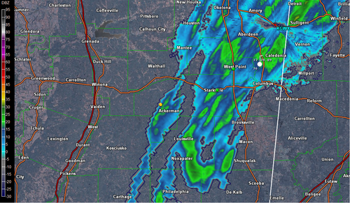
radar imagery reveals lingering showers over the Golden Triangle Region
with temperatures hanging out mainly in the mid 30s.
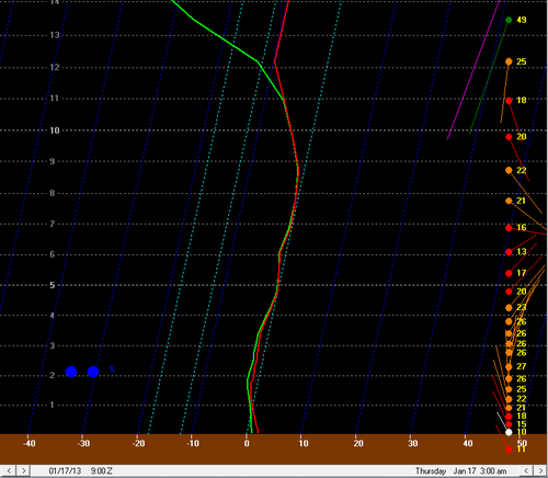
Rain showers will continue overnight but as a cold upper-level low continues to move closer to the area, the above surface air will begin to cool off. This will result in the elevated melting layer disappearing throughout the overnight as evidenced by the 18Z NAM run for 3am local time below. During the couple hours leading up to this time period, the elevated melting layer would be shallow and cold enough to support sleet but other issues will likely prevent this. The issue is that the best snow growth region does not occur until around 17,000 feet at 3am. Snow could form at lower levels possibly down near 12,000 feet but even at that height, the cloud height is not reaching these levels. Therefore it is my concern that while the atmosphere could support snow, dendritic crystal growth will not start to occur and thus precipitation will fall as either rain or freezing rain depending on the surface temperature.
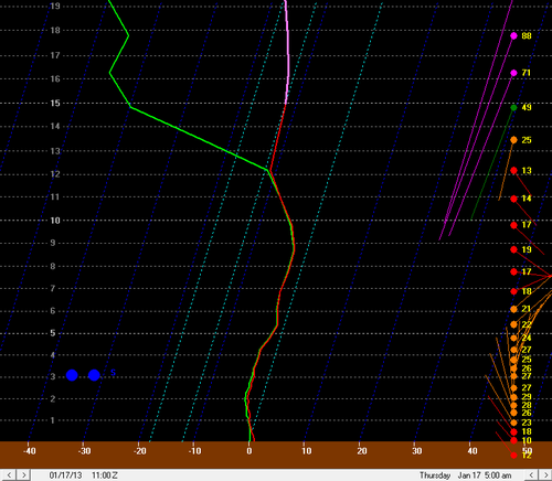
Just a couple hours later though, the 18Z NAM does show the cloud heights growing to a point where dendritic crystal growth could occur, though not optimally. At this stage an hour or two before sunrise, I would expect very wet snow to begin falling with low snowfall ratios as most of the layer is near freezing, nearly maximizing riming potential.
As the sunrise nears, the clouds will finally reach an area for optimal dendritic crystal growth and as the layer continues to cool, snowfall ratios will increase. Snow will likely continue to fall all morning before mixing with rain around noon and ending as rain showers in the early afternoon. The 18Z GFS also supports a solution similar to this.
This specific event does have a few things going for it. One, the NAM specifically has really struggled with understanding just how cold this air mass is. Today’s high should have been in the low 40s according to the NAM in the Starkville area but the actual high was only 37 at KGTR. Additionally, upper air temperatures upstream have been confirming a couple degrees cooler than the model soundings have been showing. These two model errors could mean cooler temperatures at the surface and above the surface overnight resulting in a higher chance of freezing rain and some potential at a quicker turnover to snow.
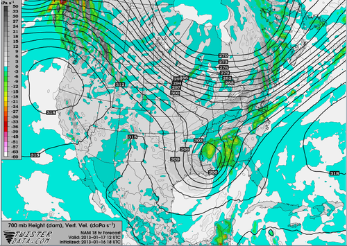
Taking a look at precipitation amounts now, strong PVA should effect the region tomorrow morning, enhancing uplift. Diffluent flow aloft will also help uplift during the early morning and mid-morning hours however, the left rear quadrant of the jet may hinder some of this uplift later in the morning. Additionally, warm air advection from the north may help with uplift. The below image from the 18Z NAM depicts this uplift occurring around sunrise tomorrow.
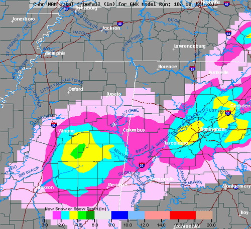
So what am I expecting for snow totals? The 18Z GFS would support a couple inches whereas the 18Z NAM supports anywhere from 2 to 4 inches. I expect these snowfall totals will be about correct given the upper air support but given that this is the first snow of the year for this area, the wet ground conditions, and near freezing surface temperatures, I expect ground accumulations to be limited. Snow will stick first to colder surfaces such as grass and trees where up to an inch may be possible but on roadways I would expect all snow to melt except on bridges where some slush could develop.
If some heavier snow can develop, as sometimes occurs with these kinds of systems in the Deep South, it would not be out of the question that minor accumulations could occur on area roadways but at this time I would not expect this to occur. Nevertheless, be sure to allow extra time to travel tomorrow and to follow winter weather driving tips such as limiting the use of your brakes and allowing extra distance between you and the vehicle in front of you.
No comments:
Post a Comment