Sunday, April 29, 2012

More Storms to Rattle the Plains and Midwest

Originally posted on ZoomRadar

Severe weather has been relatively quiet across the country since the April 14th tornado outbreak which struck the Great Plains. However, over the past few days things have begun to heat up a little more. Yesterday resulted in over 200 hail reports with 44 of these reports being two inches in diameter or greater. Strong wind gusts also resulted in the death of one and injuries to about 100 people when a large tent was blown over in St. Louis following a Cardinals baseball game.

The number of reported tornadoes has remained fairly low though, with only 44 tornado reports over the past two weeks. With more storms set to rumble for the next few days, it is likely we will add to this number but perhaps not by much. Though Tuesday does appear more favorable and will definitely be something to keep an eye on as it approaches, the parameters needed for another spring tornado outbreak just do not appear to be lining up at this point.
Below is the Storm Prediction Center Day 1 Outlook depicting a slight risk for severe thunderstorms today across portions of eastern Colorado, northeastern New Mexico, the Panhandle of Texas, and parts of Kansas, Oklahoma, and Missouri. The main threats today will be damaging winds, large hail, and a couple isolated tornadoes.
Tomorrow the threat of severe storms targets the eastern portion of the Texas Panhandle, as well as much of Kansas and Oklahoma. Additionally, an area which saw strong to severe storms yesterday, including the southern portions of Illinois, Indiana, and Ohio, will be under the gun again tomorrow as shown in the Storm Prediction Center’s probabilistic Day 2 Outlook below. The main threats yet again are damaging winds, large hail, and a couple isolated tornadoes. The hatched area in the graphic below may even be at risk for some very large hail as steepening lapse rates and instability appear very favorable for this area.
The Day 3 probabilistic outlook from the Storm Prediction Center shows a slight risk area stretching from central Kansas northward to the Minnesota-Canadian border. An elevated slight risk is present in the middle of this slight risk and may be something that needs to be monitored for a moderate risk as the time of this event gets closer. Once again though, damaging winds and large hail will be the main threats though supercells may have a better chance of developing during this time period which may result in a few more tornadoes.
What is limiting the tornado risk you might ask?
The easy answer is a general lack of quality shear in the areas at risk for thunderstorm development. When good shear exists, it has typically been isolated in nature. The next few days seem to show this same trend of a lack of good shear. The issue with the shear is not even so much directional as it is speed. With a weak jet stream and slow low-level jet, thunderstorms will have a hard time finding enough speed shear to get rotating at faster rates, thus limiting the tornado threat. In addition to the limited shear, instability has remained marginal many days with caps not allowing the air to really get rising for thunderstorm development.
Will these limitations break anytime soon?
It appears conditions for tornadoes will become more favorable on Monday night as the low-level jet begins to pick up across the Plains. The best chance, like I said earlier, could be Tuesday into Tuesday night. Take a look at some of the parameters below as depicted by the latest run of the NAM model for Tuesday afternoon and evening.
The image below shows CAPE for Tuesday afternoon. Large areas of 2000 J/kg plus depicted in yellows and reds and even 3000 J/kg plus depicted in reds exist across a large portion of the threat area. With so much energy waiting to be tapped, the question exists now of whether caps will yet again keep this CAPE from being used. It appears this may be the case early on in the day but by the evening and into the early hours of the overnight Tuesday, conditions appear favorable.
Shear may still be an issue though and this is why the number of tornadoes could still be limited despite having enough instability to support thunderstorm development. Surface to 500 mb bulk shear appears somewhat favorable at times over different areas but helicity values remain generally low. The effective helicity index shown below for Tuesday afternoon, appears at least marginally favorable for many areas and alludes to the fact that a few isolated areas will likely be quite favorable.
While the low-level jet does strengthen Tuesday night, it mainly does so over the southern portion of the risk area as depicted below for Tuesday night into Wednesday early morning.
The jet stream on the other hand remains towards the northern portion of the risk area as depicted below for the same time as the above image.
This is the issue for speed shear across the Plains during this period. So while the parameters exist, it appears they will just not line up enough to create a tornado outbreak and therefore as it stands right now, only an isolated threat for tornadoes should be expected. That being said be sure to keep an eye on this event because if that low-level jet strengthens a little more than currently expected or the jet stream drops a little further south, Tuesday evening into Tuesday night could get quite interesting across the northern portions of the elevated slight risk highlighted in the Day 3 Storm Prediction Center outlook.

Tuesday, April 24, 2012

Northeast Snowstorm Recap

Originally posted on ZoomRadar

After a mild winter, a historic late season snowstorm hit parts of the interior Northeast over the past couple days. Snow showers are finally coming to an end across the areas affected as the storm system continues its push northward. Many daily snowfall records were broken and some areas saw storm snow totals of over one foot! Below is an image depicting the snow depth as of this morning. Keep in mind that this snow will melt fairly quickly and some of it has already started to do so.

The image does show that the snow piled up and still existed this morning across the hills and mountains of West Virginia northward into Pennsylvania and parts of upstate New York. Additionally some areas in Vermont, New Hampshire, and Maine picked up some light snowfall. Some of the higher preliminary snowfall reports from the storm are from Laurel Summit, PA where 23.2″ fell, Sinclairville, NY where 15″ fell, Cattaraugus, NY where 12.8″ fell, Warsaw, NY where 12″ fell, near Sylvania, PA where 11″ fell, Oakland, PA where 8″ fell, Estcourt, ME where 8″ fell, and Frostburg, MD where 6″ fell.
The track of the storm, shown below in a few images, varied somewhat from what the models were predicting on Friday afternoon when I last wrote about this storm system. The eventual track of the storm actually started off in good agreement with the 12Z Friday GFS before beginning to look more like the 12Z ECMWF. The problem was that no model really forecasted the initial low to weaken as it continued north out of New York City and for a secondary low to form off to its east and take a track toward the north from there. This initial pull of the track farther east than many expected was the reason that Sunday night into Monday morning, many areas on the eastern edge of where the snow occurred were surprised. Residents of those areas went to sleep thinking they may wake up to a dusting of snow or maybe even an inch and instead woke up to inches of snow with newly posted winter weather advisories and winter storm warnings.
Storm system just after it makes landfall on Monday morning with the low pressure traveling northward from central New Jersey to New York City where it reached 986 mb.
Storm system on early Monday afternoon with low near Albany, NY at 988 mb.
Storm system on late Monday afternoon with low over the Adirondack Mountains at 987 mb.
Storm system on Monday evening with initial low over the Adirondack Mountains at 988 mb and a new low over the eastern end of Lake Ontario at 989 mb.
Storm system in the early morning hours on Tuesday with initial low over northern Vermont weakening now at 990 mb and new low deepening over eastern Lake Ontario at 986 mb.
Storm system now with only the new low just north of Lake Ontario at its lowest pressure of 985 mb just before sunrise on Tuesday morning.
Storm system Tuesday mid-morning as it continues to push northward and begins to weaken with the lowest pressure now only at 986 mb.
The surprise snow caught some off guard though it should have been expected in my opinion. The exact track of this storm was never fully certain and therefore deviations of tens of miles were quite possible which would lead to deviations in the areas receiving snowfall. My alma mater, Cornell University, which is located in Ithaca, NY picked up right around 6″ of this surprise snowfall on Sunday night. The fact that the storm system dumped much of its snow on areas farther east than expected on Sunday night actually helped keep storm snowfall totals down as Monday night the snow fell over areas further to the west where it was predicted to fall. While this did cut down on the amount of damage done to trees and power lines, some areas still saw their fair share of damage and power outages. Despite the damages, the snow came as good news to some such as Seven Springs Mountain Resort which had previously closed their resort to skiing and snowboarding, announced that they will open the resort for one last day of skiing Tuesday. This will be the latest date this ski resort has offered skiing and snowboarding since it opened.

Friday, April 20, 2012

Snow for Parts of the Northeast?!

Originally posted on ZoomRadar

Following a winter which was very warm and had little snow when compared to average, who would believe that we would be talking about a chance of snow in late April? Well, believe it. Although the weather models are not quite in agreement on where this snow will hit, they are in agreement that some places will be under the gun for a late April snowfall. Let’s take a look at what the NAM, GFS, and the ECMWF models are predicting right now as we get ready for what could be a very historic late season event.

A low pressure system is expected to form over the Gulf of Mexico Saturday afternoon just off the coast of Florida. From here the low will ride the eastern seaboard up the coast. This is what the models agree on. Where they differ is on the exact track of the low once it reaches the northeast. The image below is of the NAM model predicting what this low may look like on Monday morning. The NAM has the low the deepest of any of the models at 980mb and almost directly over central New Jersey. I have done my best job to highlight the past path and future path of the low as depicted by the NAM in orange. As you can see, the NAM projects the low to continue heading toward the northwest into western New York throughout Monday. The NAM model only goes out 84 hours so it is unclear where this model may take the low after this but if the other models are any indication it will most likely begin to head northward. The other thing of note here are the wind speeds, reaching at least 20 knots and in some areas 30 knots plus. These wind speeds coupled with the snow that would be falling could very well create for blizzard like conditions in western New York and parts of northeast Pennsylvania.

The GFS model on the other hand does not depict as strong of winds but the winds still could be quite gusty under this scenario, shown below. The GFS leaves the low a little farther out to sea instead being located over the New York City area on Monday morning as a 988 mb low, which is not nearly as intense as the NAM predicted and thus why the winds are weaker. From here the low is modeled to move toward the north northwest into northern New York before retrograding into Ontario and moving north.
The ECMWF track, which I show below on a simple U.S. map, has about the same position over central New Jersey as the NAM model did for Monday morning but the intensity of the low only ever reaches 984 mb and is only 988 mb at this point on Monday morning. The track from here is very interesting as it progresses a little more northerly than the NAM track did putting it on the eastern shore area of Lake Ontario before it retrogrades to almost the opposite shore of Lake Ontario and then begins to head northward.

Despite the track differences, enough cold air will exist to create snow on the western side of the low. Below are images from the NAM showing the 1000-500 mb thickness near the onset of snowfall and then again on Monday evening when the storm would probably start to move northward after retrograding some. It is of note here that the GFS depicts a very similar looking scenario but has less wrapping of the cold air occurring around the south end of the low and less wrapping of the warm air occurring north of the low. This is most likely due to the GFS predicting a less intense low pressure. The line to note in these images is the 540 line which typically depicts the rain/snow line in these storms though in late season storms, snow can occur at thicknesses of 5460 or less. So areas in blue would be cold enough for snow and maybe even the lightest first shade of green.


Now this does not mean just because an area is below the 540 or 546 thickness threshold it will snow, as moisture and cold temperatures at the surface still need to be present. There will be plenty of moisture with this system as shown by the HPC’s image below showing precipitation over the next five days. Many areas across the northeast will pick up at least two inches of precipitation with some areas seeing in excess of four inches.

The cold temperatures will be the tricky part of the forecast and something that will need to be monitored as the event gets closer. Some areas are for sure cold enough for snow at the surface and other areas will be right around the freezing mark with what could play out as interesting temperature profiles aloft. The one threat that has not been mentioned by anyone yet with this storm is freezing rain. At this time it does not appear this will be a big freezing rain maker but if the NAM is right and the low deepens more, wrap around warm air advection could allow profiles to warm enough aloft to lead to some freezing rain in areas north of the low.
Below are the current predicted snowfall depths from the NAM (top) and GFS (bottom). The GFS image is from 12 hours after the NAM image and therefore the NAM may actually have more snowfall falling than is depicted in this image. As you can see the NAM is predicting more snowfall than the GFS but both of these models have come into some agreement on a general area of snowfall from the mountains of West Virginia northward into western New York and Ontario.

The ECMWF on the other hand appears to give a solution more similar to the GFS with a little more snow expected for parts of northern New York. It will certainly be interesting to see how this plays out but the threats of heavy rain, wind, snow, and maybe some freezing rain are apparent. Below is a map of what I am thinking could be the threats as far as precipitation type goes.
The green areas should be ready for rain, of which some could be locally heavy in excess of four inches. The orange area is the mixed bag area. Here we could see all rain, all snow, or something in between. These are the areas that really need to monitor the future forecasts on this storm to see if they need to prepare for any snow or freezing precipitation. Areas particularly in danger could be northern New York, especially the Adirondacks, and parts of the mountains in southern New York and Pennsylvania. If the low does not deepen as much these areas could see more snowfall as less warm air wraps around the low. The area that should see all snow is highlighted in blue with dark blue depicting an area that is at the greatest risk right now. This greatest risk area could see snowfall amounts in excess of six inches which could cause power outages due to the fact that many trees have their leaves or have started getting their leaves. This heavy snow coupled with blustery winds could mean many trees and power lines would be down across this area. Definitely pay close attention to the developments on this storm throughout the weekend as the forecasts for this storm are anything but set in stone.

Monday, April 16, 2012

Thoughts on the Recent Tornado Outbreak

Originally posted on ZoomRadar

The event the Storm Prediction Center had been warning people of since early last week struck with vengeance this weekend across the Plains. As of Monday evening a total of six people had lost their lives and many others had been injured. The outbreak could have been much worse though, both in terms of the number of tornadoes and losses. First let’s focus on the losses and why they could have been worse.

This was the first major tornado outbreak that has occurred where the National Weather Service was able to deploy their experimental, more strongly worded, tornado warnings for situations where tornadoes have been confirmed on the ground or are very evident on radar and therefore strong tornadoes. These warnings, along with the typical warnings, have been given much credit in the news these past couple days for keeping deaths and injuries to lower levels than they could have been. While it is likely that these new warnings helped, meteorologists also did a particular good job of issuing warnings when warranted during this event, as shown in the image below.

There is only one tornado report in the image above that appears to fall completely outside of a tornado warning. But even this incident was subsequently issued a tornado warning just a few minutes later. It also appears, by visual inspection, that a surprising amount of the tornado warnings issued will confirm when considering that only about one out of four tornado warnings typically confirms. Additionally, all but one tornado warning occurred inside the tornado watch boxes and this warning has no report with it so there may have actually been no tornado. The National Weather Service and the Storm Prediction Center did a great job of warning people when danger was possible and this definitely kept fatalities and injuries to a minimum.
That being said, losses could have been much higher despite the warnings. One particular storm that had a history of producing tornadoes moved into the southern Wichita area shortly after 10 pm local time. Out of all of the tornadoes on Saturday, this tornado arguably produced the highest concern as it approached the Wichita metro area. Not only was the tornado heading for a city of nearly 400,000 people but it was heading towards this city on a Saturday night when many events were occurring in the city. One event that came under scrutiny was a concert held at Intrust Bank Arena headlining country music singer Miranda Lambert. The event that brought in a crowd of about 6,000 people, according to reports, had to be suspended for about 45 minutes while the EF3 tornado passed just five miles to the southeast. Concert goers were told to remain in the bowl of the arena while the storm passed. If this storm would have had a slightly different path the results could have been devastating. The Wichita area had been under a Particularity Dangerous Situation (PDS) Tornado Watch since a little after 5 pm local time that evening which prompted some to question why the event was allowed to go on with the recent memory of last year’s Sugarland incident at the Indiana State Fair fresh in everyone’s minds. A key difference here however was that this most recent event was indoors and luckily the tornado missed the arena whereas the Indiana State Fair was hit directly by strong wind gusts which caused a stage collapse and seven fatalities.
In general, most of the tornadoes remained over rural areas on Saturday which helped keep the number affected by them to a minimum. Not every town was so lucky however. A tornado struck Woodward, OK shortly after midnight local time. The tornado sirens, according to reports, never sounded due to some error with the system which may have been caused by a lightning strike. While this was a very unfortunate incident, it is yet more proof that the technology behind tornado sirens is outdated and should not be relied on to serve as a source of warning in the event of a tornado. Meteorologists can only do so much when it comes to warning people and at some point it becomes the responsibility of citizens to make sure they have the necessary means to receive notifications of watches and warnings. This was the only tornado which produced fatalities from this outbreak and who knows what would have occurred if the sirens did sound that night.
So what about the outbreak itself, could it have been worse? The answer in my opinion is definitely, as many areas put under a high risk and/or tornado watches by the Storm Prediction Center saw no severe weather at all. The graphic below depicts the Day 1 Outlook from the Storm Prediction Center along with the reports received from Saturday and Saturday night. All together there were 135 tornado reports, 168 severe hail reports, and 76 severe wind reports.
You may notice that some areas highlighted as at risk in this image saw little or no severe weather on Saturday. First let’s focus on what happened, generally speaking. The day kicked off with supercells across the middle of the risk area which tracked across portions of Kansas and into parts of Nebraska. Farther north, line segments tended to dominate which actually pushed into Iowa and into Illinois. Later in the day more supercells formed across northwestern Oklahoma, Kansas, and parts of Nebraska which was then followed by a large line of storms which extended from Texas into Nebraska and continued pushing east throughout the night. Three areas that stick out to me that missed out on the severe weather are the southern portions of the risk area, the northern portions of the risk area, and lots of the eastern portions of the risk area. The southern portions suffered from a lack of forcing and despite having great parameters, storms would just not initialize over this area. The northern portion suffered from a completely different issue as early morning storms tended to restabilize the environment which hindered the ability for stronger storms to form later in the day. Lastly, the eastern portions just missed out on the main energy for the system which meant when storms finally arrived to these areas in the overnight, they were no longer severe. If some of these things would have turned out differently we could have seen a lot more tornado and severe weather reports on Saturday.
So will people remember this outbreak? Well, it is certainly an outbreak which will remain in the minds of people across the Plains for some time. However, due to the lack of widespread devastation and death, it is likely that a few years from now this outbreak will not be remembered as anything too significant from any other tornado outbreak. Unfortunately the human mind tends to only remember events which cause widespread loss and therefore it is likely this event will fade into the many other tornado outbreaks that have occurred in the past.
Regardless, the outbreak produced many tornadoes which were captured by many storm chasers and non storm chasers throughout the day. Below are some images which I captured on the ZoomRadar map on Saturday thanks to the SevereStudios Storm Chasers network.
Steve Worthington on a tornadic supercell near Marquette, KS.
Steve Worthington approaching the EF4 tornado near Marquette, KS.
James Skivers on the same supercell as Steve Worthington near Marquette, KS.
Great shot by Steve Worthington near Marquette, KS of the EF4 tornado.
The same tornado being chased by Steve Worthington as it begins to weaken near Marquette, KS.
Matt Walker chasing a possible tornado near Waynoka, OK which has yet to be rated/confirmed.
Kevin Brown chasing a tornado near New Cambria, KS from the same supercell which produced the EF4 tornado earlier near Marquette, KS.

Friday, April 13, 2012

Stormy Weekend for the Plains

Originally posted on ZoomRadar

The past few days started with the hype of severe storms potentially breaking out across areas of the Plains. The results however, were very few storms initiating or very few storms reaching severe criteria depending on the day. Only a few tornadoes occurred over the past few days, of which one took place in California, and each day continued to be a bust compared to what was predicted. This is not to say some severe weather did not occur. Woodward, OK made news with baseball size hail plummeting the town as well as the Amarillo, TX area which saw large amounts of hail fall out of a nearly stationary cell which caused the closure of part of route 287 and hail drifts up to four feet deep! For most areas however, the cap would just not break and when it did, nightfall was right there, putting an end to the increase in instability. Yesterday widespread cloud cover made it nearly impossible for storms to develop due to the lack of heating. Now with a potential deadly tornado outbreak set to occur this weekend the questions remain, will the storms actually develop this time and with the recent busts, will people actually take the threat seriously?

Let’s start with today. The SPC Day 1 Outlook below shows parts of southwestern Missouri, southeastern Kansas, most of Oklahoma, and parts of northern Texas in the slight risk with the main threats being damaging hail with some severe criteria wind gusts as well.

Additionally, the SPC has once again warned about the risk of tornadoes for today, as shown below. The highest risk carries with it a 10% chance of a tornado within 25 miles of a point as well as a 10% or greater probability of an EF2 or greater intensity tornado within 25 miles of a point.
Now this seems pretty significant but let’s put it into perspective. The SPC has issued threats like this many times before, including yesterday when only one tornado was reported. That being said though, yesterday’s storms were hampered by cloud cover limiting solar heating during the day which made it difficult for rising air to be able to break the cap. Today, this cloud cover does not exist, or is at least not as widespread. Taking a look at the latest surface observations, temperatures appear to be warming up nicely as of late this morning and dew points are high as well, with readings in the low to mid 60s.
Based on the heating that has already occurred today, and is forecasted to continue throughout the day, and the lack of cloud cover this morning that allowed this to happen, I would expect that storms will actually break out this afternoon. In fact, the SPC has just issued the first tornado watch of the day which will be in effect until 9PM CDT due to the initiation of some of these storms already this afternoon.
Additionally, 0 to 3 km storm relative helicity and surface to 500 mb shear values from the NAM model, shown below, appear to be very favorable for just after sunset this evening. It appears these values will be marginal throughout the day but really line up early tonight and actually continue through the overnight as the 850 mb low-level jet continues to strengthen.
The bad part about this, is that most of the tornadoes that form will be at night tonight making them even more dangerous due to people not being able to see them or people just not getting the warnings because they are asleep. This is a weekend though, that residents of the Plains will need to remain alert because tonight is just the beginning to a long weekend of tornado threats.
Saturday is when things will really get serious. Below is the Day 2 Outlook from the SPC which depicts a high risk now for areas in northern central Oklahoma, southern central Kansas, parts of eastern Nebraska, and parts of western Iowa. This is only the second time the SPC has issued a high risk for a Day 2 product with the other time being an issuance for an April 7, 2006 event which produced over 70 confirmed tornadoes, though a few of these occurred the day before and after. Overall, April 7th was responsible for 91 tornado reports.
The probabilistic Day 2 Outlook, shown below, shows just how high of a risk some areas of the Plains will be dealing with on Saturday and Saturday night. The high risk areas from above are looking at a predicted 60% chance of severe weather within 25 miles of a point with another 10% or greater probability of significant severe weather within 25 miles of a point. Outside of this high risk threat, there is a very large area which is still in a slight or moderate risk for severe storms, with the moderate risk area being hatched for the 10% or greater probability of significant severe weather within 25 miles of a point.
While some storms may form during the afternoon, it appears the bulk of the activity will occur after dark. This will yet again make this outbreak more dangerous to life. The models are not picking up on a tremendous amount of precipitation from this event but given the forcing associated with the movement of the dry line and cold front across the Plains, this should be enough to lead to uplift capable of producing thunderstorms. It should also be noted that weather models tend to have a more difficult time picking up on mesoscale processes such as thunderstorms and this could also be a reason why the models are failing to produce many storms Saturday afternoon and evening. Once these storms form though, the physical parameters of the atmosphere will once again be very favorable. Below are the NAM model output for 0 to 3 km storm relative helicity and surface to 500 mb shear for Saturday night around midnight.
If storms are occurring during this time, which despite what the models are predicting they should be occurring, we could be looking at a major severe weather outbreak including multiple tornadoes. The low-level jet will be very strong across the threat area and this will definitely help aid in keeping the severe weather going throughout the night. This event is one that should not be taken lightly and the resident of the Plains should be keeping a close eye on it.
After Saturday night, which should be the worst of this event, the system will continue to push eastward. The SPC Day 3 Outlook is shown below depicting a slight risk for an area in and around Wisconsin as well as an area from southern Missouri south southwestward toward eastern Texas. This later risk area appears to have the best threat of severe storms on Sunday.
The threat may be more for line segments across Sunday and into Sunday night however. Shear and helicity values will not be very strong on Sunday but will strengthen again on Sunday night though due to the nature of the storms, tornadoes should not be as large of a threat. If supercells could form out in front of the main line of storms on Sunday night however, then tornadoes may become more of an issue but at this time it is hard to tell if the atmosphere will be unstable enough to produce these. The storm system will continue to push east Monday likely posing more areas at risk for severe weather to the east of Sunday’s threat area.
This could be a very large severe weather outbreak and with the bulk of the activity occurring after nightfall, it is of the utmost importance to remain aware of what is going on. Severe Studios storm chasers will be chasing all day today as well as Saturday and into Sunday so be sure to keep an eye on them on the ZoomRadar map if you are in an area that is safe to do so.
Be safe everyone!

Monday, April 9, 2012

Days of Severe Weather for the Southern and Central Plains

Originally posted on ZoomRadar

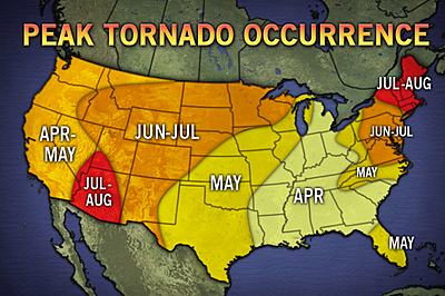
It has been an odd year for weather across the United States. Typical winter cold and snow never really showed up for most of the lower 48 this year. This meant spring like weather started much earlier than normal and now it appears that this has shifted the typical timing of the severe weather season this year. During a normal beginning of April we would expect to see the highest risk for tornadoes to be mainly over the southeast and into parts of the Midwest as shown in the image below.


Courtesy of thewatchers.com
However, this April we will likely being seeing more of a threat across areas that are more likely to see their tornado occurrences peak in the month of May. This will be especially true this week as parts of the Southern and Central Great Plains gear up for severe weather. Some areas will even see the threat of severe weather multiple days in a row which is something that does not typically happen in this region until May also. So where can this severe weather be expected this week?

Let’s start with today’s storms which have just begun to fire up across parts of the Southern Plains. The latest SPC Day 1 Outlook is below with a small area I have circled in black depicting where there is a 5% chance of a tornado within 25 miles of a point today based on SPC predictions.

Let’s take a look at where the NAM model predicts conditions may be best for tornadoes today and tonight now. General things I will note first before getting to a couple graphics are that these storms will be aided by some strong winds aloft, particularly a nice area of 50 knots or greater wind speeds at the jet stream level. However, only a weak 850 mb low-level jet will be present. Warm air advection will be present in some areas to aid in rising air, but overall it will not be that impressive. What will be more impressive however, are CAPE values which are predicted to reach above 2000 in some spots this evening, as shown below. This means there will be lots of unstable air to aid in thunderstorm development in these regions.
These areas with higher CAPE values will also benefit from low lifted condensation levels this evening and throughout the overnight hours. This means that rain, hail, and tornadoes have an easier time making it to the ground because the cloud bases are lower to the ground. However, the best shear values will not occur until later tonight around the midnight hour and into the early morning hours according to the NAM model. Below is the predicted 0-3 km helicity values for tonight around midnight. The best threat area will likely be the reds across southeast Oklahoma and into Texas.
Coupling this with the surface to 500 mb shear values, we see the highest shear values take place in about this same area. I would expect this area to have the highest risk of tornadoes tonight.
Outside of the tornado threat, large hail and some damaging winds will be the main concerns this evening and tonight. Already this afternoon 4.25″ hail was reported in Woodward, OK which caused at least some window damage according to the storm report. So where does the threat appear to be for the rest of the week?
Well, it will be the same story as today basically, with a dry line off to the west and some kind of cold/stationary front to the north, a warm sector will be created that will be favorable for storms. The only difference from day to day will be the locations of these features as they will tend to move back and forth a bit. The Day 2 Probabilistic Outlook from the SPC is below, I have circled in black the area I think has the highest threat of tornadoes during this period.
While storms should benefit from some warm air advection tomorrow, shear will be low for most of the time, limiting the tornado threat. My circled area has some better bulk shear values as well as helicity during the first part of the overnight and therefore this is where I would look for tornadoes to potentially form, though as I said the overall threat is fairly low. Outside of tornadoes there will likely be some more large hail and damaging winds though it appears tomorrow and the next day may be the least active day for severe weather this week.
Moving onto the Day 3 Probabilistic Outlook from the SPC now, I have once again added my black circle for the area with the greatest risk of tornado threat in my opinion which is only a little better than the chances on Day 2.
Warm air advection will not play a large part in helping storms form this day. Rather storms will be mainly initiated by the frontal movements. Shear values appear slightly better than the day before and therefore I think the tornado threat will be slightly more than the previous day but still nowhere near an outbreak type scenario.
Now this is when things could get a little more interesting. The SPC has highlighted areas for Day 4, Day 5, and Day 6 which they consider to have a 30% or greater probability of severe weather within 25 miles of a point on that day, shown below.
The threat over these days could be much greater for tornadoes as shear values tend to look much better, granted these events are quite a ways away yet. As of right now I would say the best times for tornadoes would be Thursday night, Friday afternoon and night, and again on Saturday afternoon and night as shear values seem to get better as this week progresses. The weather models begin to diverge more on a solution after this but it appears severe storms could continue on Sunday slightly to the east of the Day 6 area and then again on Monday across a large area around the Mississippi River valley. In fact, it is possible severe weather could continue all the way until Thursday as this storm system pushes off the east coast after swinging through the southeast.
April is going to start bringing the severe weather this week and into next week. Please remain weather aware and check out the latest ZoomRadar radar image to see where the storms are at and where the storm chasers are chasing live!