
 |
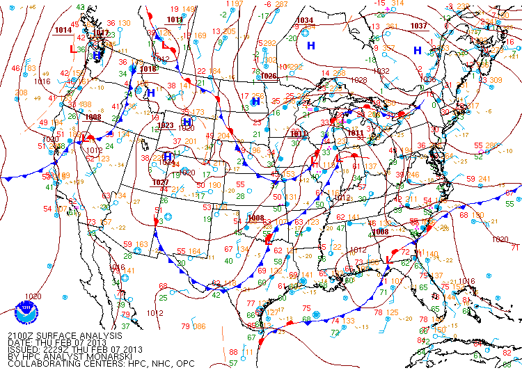
| Surface chart as of late this afternoon |
A major winter storm is set to begin tonight and continue through Saturday night in some areas of the Northeast. A low pressure system, currently located around northern Illinois, will move east tonight into northern Ohio by morning. Meanwhile, another low pressure system, currently located along the Georgia and Florida border, will push up the east coast tonight reaching the North Carolina coast by morning. By Friday evening, the coastal low will be located off the coast of New Jersey and Delaware, where it will merge with the energy from the Midwest low pressure. As this happens, the coastal low will deepen dramatically reaching sub 980 mb readings according to the 18Z runs of the NAM and GFS. The peak strength of this low will be overnight Friday off the coast of New England. This will be when the heaviest snow falls and when the gustiest winds occur then. By Saturday morning, the low will start to weaken and move slowly to the east throughout the day. Only a few lingering snow showers will likely remain across portions of New England, especially near the coast, by the time Saturday night comes around.
So when can you expect the precipitation to begin in your area?

To the right is a map I made depicting the onset of the precipitation from either of the lows. The earliest onset of precipitation is occurring right now across areas near Lake Ontario as snow slowly begins to cover this area. By tomorrow morning, snow will be covering many areas across Upstate New York, Vermont, and the western portion of New Hampshire, Massachusetts, and Connecticut. Most of this will be in the form of snow associated with the low originating from the Midwest. Precipitation will also be occurring across Ohio from this low. Meanwhile, the coastal low will be responsible for rain, snow, and sleet starting by tomorrow morning across eastern Pennsylvania, New Jersey, and the lower portion of New York and Connecticut. By midday precipitation will encompass most of the Northeast. Northern Maine will be the last are to see the onset of snow, occurring either tomorrow afternoon or tomorrow night. It should be noted that this denotes only when the precipitation will begin for an area and not when the heaviest snow will be.
So when will the heaviest snow fall in your area?
 To the right is a map I made showing when the heaviest snow will likely fall in each area. Keep in mind that this is the heaviest snow with respect to each area. This means that some areas will receive heavier snow than others but this map does not take that into account. In general, the areas receiving the heaviest snowfall will begin in the west and move toward the north and east as the time period progresses.
So how much snow can you expect?
 Snowfall totals are still in question for some areas as the exact track of the lows, especially the coastal low, could result in drastic changes in snowfall. For instance, in the 18Z run of the NAM and GFS models, the NAM runs the coastal low a little closer to the coast. This means the difference between 18" plus of snowfall for New York City with the NAM track and 5" to 10" for the GFS track. With that in mind, to the right is my prediction for snowfall totals starting this evening through Saturday night from this system. This will be the first major winter storm for many of these areas in nearly two years. The heaviest snowfall
 totals appear as though they will span from near New York City northeastward into southern Maine. One thing to consider is that especially along the coast, strong winds will also accompany this snowfall resulting in blowing and drifting snow. To the right is what I expect for wind gusts during the event. For most areas wind gusts will only cause minor drifting and blowing. However for coastal Maine, southeast New Hampshire, eastern Massachusetts, Rhode Island, Connecticut, and Long Island, winds could cause major drifting of any accumulated snow and result in some isolated power outages from falling limbs and perhaps a few trees. People in these areas should be prepared for the worst case scenario that they could be without power during the winter. Temperatures Saturday night after the storm will be quite cold too with most areas getting down to 20 or lower. Some areas will even see temperatures at or below zero.
Bottom line, if you do not need to travel during this storm, don't! Stay safe everyone.
No comments:
Post a Comment